Difference between revisions of "2011-11-02 62 17"
imported>Fasanen (Expedition report) |
imported>Fasanen (Fixed coordinate format for OSM-link) |
||
| Line 23: | Line 23: | ||
== Photos == | == Photos == | ||
<gallery perrow="4"> | <gallery perrow="4"> | ||
| − | Image:2011-11-02_62_17_12-07-35-424.jpg | The hash! [http://www.openstreetmap.org/?lat=62 | + | Image:2011-11-02_62_17_12-07-35-424.jpg | The hash! [http://www.openstreetmap.org/?lat=62.3522&lon=17.2823&zoom=16&layers=B000FTF @62.3522,17.2823] |
| − | Image:201111026217_01.png |We | + | Image:201111026217_01.png |We were there |
Image:201111026217_02.JPG |A muddy start | Image:201111026217_02.JPG |A muddy start | ||
Image:201111026217 03.JPG |Fågelberget is the way | Image:201111026217 03.JPG |Fågelberget is the way | ||
Revision as of 19:40, 3 November 2011
| Wed 2 Nov 2011 in 62,17: 62.3522391, 17.2822689 geohashing.info google osm bing/os kml crox |
Location
Clear-felled area one klick south from Sidsjöbodarna, Sundsvall, Sweden.
Participants
- Fasanen and his father.
Expedition
- Success in new graticule! -- Fasanen @62,3522,17,2823 07:04, 2 November 2011 (EDT)
On autumn vacation visiting my parents in my "youth graticule" 62 17 (Sundsvall), I was lucky to find that the coordinates were not that far from my old home. It was not a hard job to persuade my father to go try to get to this geohash as it was going to be a historical event to deflower this graticule.
We parked the car a just over a kilometer from the hash an started walking on muddy but easily walked paths. Soon we got to a power lane where the terrain got a bit rougher. We made our way trough a bit of swamp, thick brush wood and slippery rocks before we got to the geohash where we planted a small pole.
On our way back we discussed the possibilities of the pole ever being found by anyone and we came to the conclusion that it might as well have been planted on the moon.
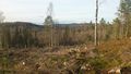
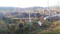
Photos
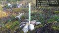
The hash! @62.3522,17.2823
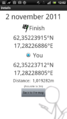
We were there
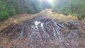
A muddy start
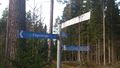
Fågelberget is the way
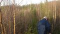
Trough brush wood
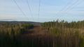
The power lane
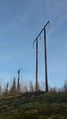
The power line
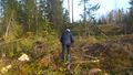
Father on his way
The surroundings
The pole


Achievements
Fasanen and his father earned the Land geohash achievement
|