Difference between revisions of "2011-11-20 47 6"
imported>TheOneRing (→Achievements) |
imported>Jiml m (Adjust verb conjuration) |
||
| Line 13: | Line 13: | ||
== The Expedition == | == The Expedition == | ||
=== TheOneRing === | === TheOneRing === | ||
| − | This graticule is quite tricky, because the biggest part lies in France, only a small fraction in Switzerland. Today, there was a geohash in Switzerland, like everywhere else close to the edge of the graticule. That's why I wanted to go geohashing and I was lucky with the weather. I took train from Berne to Les Breuleux-Eglise via Neuchâtel, La Chaux-de-Fonds and Le Noirmont. I really don't know why some cities have an article in their name. | + | This graticule is quite tricky, because the biggest part lies in France, only a small |
| + | fraction in Switzerland. Today, there was a geohash in Switzerland, like everywhere | ||
| + | else close to the edge of the graticule. That's why I wanted to go geohashing and I | ||
| + | was lucky with the weather. I took a train from Berne to Les Breuleux-Eglise via | ||
| + | Neuchâtel, La Chaux-de-Fonds and Le Noirmont. (I really don't know why some | ||
| + | cities have an article in their name.) | ||
| − | Because the location of the geohash was special, the train station | + | Because the location of the geohash was special, the train station where I got off the train, |
| + | lay in the neighboring graticule. From the train station it was only 1.1 km as the crow | ||
| + | flies and slightly more than 2 km by foot. | ||
| − | The geohash itself | + | The geohash itself lay on a meadow near a forest, so the surroundings consisted of grass |
| + | and trees. I rather took some photographs from outside the forest to get an impression | ||
| + | of the countryside. Really nice. | ||
| − | Because 2 km walking seemed to me far too | + | Because 2 km walking seemed to me far too little I did not walk back to Les Breuleux but |
| + | on to Le Noirmont. The name is French for black hill, but the hills around were just | ||
| + | green-brown. Thereafter I took the next train back to Berne via the same cities | ||
| + | mentioned above. | ||
== Photos == | == Photos == | ||
Revision as of 01:23, 21 November 2011
| Sun 20 Nov 2011 in 47,6: 47.2202491, 6.9939718 geohashing.info google osm bing/os kml crox |
Contents
Location
The geohash is near the village of Les Breuleux (canton Jura).
Participants
TheOneRing - by public transport.
The Expedition
TheOneRing
This graticule is quite tricky, because the biggest part lies in France, only a small fraction in Switzerland. Today, there was a geohash in Switzerland, like everywhere else close to the edge of the graticule. That's why I wanted to go geohashing and I was lucky with the weather. I took a train from Berne to Les Breuleux-Eglise via Neuchâtel, La Chaux-de-Fonds and Le Noirmont. (I really don't know why some cities have an article in their name.)
Because the location of the geohash was special, the train station where I got off the train, lay in the neighboring graticule. From the train station it was only 1.1 km as the crow flies and slightly more than 2 km by foot.
The geohash itself lay on a meadow near a forest, so the surroundings consisted of grass and trees. I rather took some photographs from outside the forest to get an impression of the countryside. Really nice.
Because 2 km walking seemed to me far too little I did not walk back to Les Breuleux but on to Le Noirmont. The name is French for black hill, but the hills around were just green-brown. Thereafter I took the next train back to Berne via the same cities mentioned above.
Photos
TheOneRing
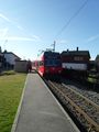
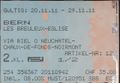
One of the trains I took
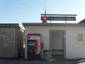
One train station in Les Breuleux (eglise means church)
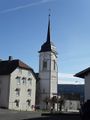
The church near the station
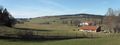
A panoramic view near the geohash
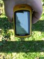
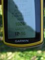
Proof that I reached the right coordinates...
...on the right date
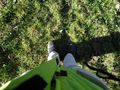
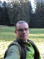
Me standing on the geohash
Some additional information
StupidGrin (unshaved, sorry, I was lazy)


Achievements
TheOneRing earned the Land geohash achievement
|
TheOneRing earned the Public transport geohash achievement
|
TheOneRing achieved level 6 of the Minesweeper Geohash achievement
|
TheOneRing achieved level 5 of the Minesweeper Geohash achievement
|
TheOneRing achieved level 3 of the Minesweeper Geohash achievement
|
TheOneRing achieved level 3 of the Minesweeper Geohash achievement
|