Difference between revisions of "2011-12-28 -37 145"
imported>Kozz |
imported>Kozz (→Photos) |
||
| Line 34: | Line 34: | ||
Image:2011-12-28_-37_145_13-50-36-585.jpg | Hashpoint in there about 5m. | Image:2011-12-28_-37_145_13-50-36-585.jpg | Hashpoint in there about 5m. | ||
| − | Image:2011-12-28_-37_145_13-51-22-960.jpg | Proof. | + | Image:2011-12-28_-37_145_13-51-22-960.jpg | Proof. The legend at top-right is coords at upload point (in car); the actual coords at the top left. |
</gallery> | </gallery> | ||
Revision as of 00:45, 30 December 2011

| Wed 28 Dec 2011 in -37,145: -37.8468062, 145.0918196 geohashing.info google osm bing/os kml crox |
Location
A suburban back yard in Burwood.
Participants
Plans
Initially: Cycle to the hashpoint from my house, about 5km as the crow flies. Actually: Too much stuff to do in the afternoon (still unpacking from the big move last weekend) so swung by on the way home from work.
Expedition
- This is under 5 km from me...so I'll look at heading out there today ord this evening. anyone else heading out? -- Kozz 05:50, 28 December 2011 (GMT+11:00)
- I'm considering heading out as well, as it's not to far from me either. Want to try and set a time and meet -- tAlex
- Sorry talex - didn't check the graticule page till I was pretty much here...nice day for a ride though! -- Kozz 13:54, 28 December 2011 (GMT+11:00)
Kozz: I took a momentary diversion on my way home from work - about 2km further south than my normal route, but less than 15 minutes added overall. There were a bunch of kids and parents in a garden across the street from number 34 (where the hashpoint lay) which restricted me from taking a decent set of photos, and the front garden looked a little wild to be wandering into, so I snapped the <10m proof, took a couple of photos and uploaded them on the fly.
Photos
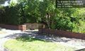
Number 34. Note the hidden raptors.
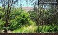
Hashpoint in there about 5m.
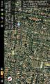
Proof. The legend at top-right is coords at upload point (in car); the actual coords at the top left.

