Difference between revisions of "2012-01-07 48 -89"
From Geohashing
imported>Jack1254 (Created page with "{{meetup graticule | lat=48 | lon=-89 | date=2012-01-07 }} == Location == About 400m past the end of Nicholettes Rd in Oliver Paipoonge, ON. == Participants == [[User:Jack125...") |
imported>FippeBot m (Location) |
||
| Line 36: | Line 36: | ||
[[Category:Expeditions with photos]] | [[Category:Expeditions with photos]] | ||
[[Category:Coordinates reached]] | [[Category:Coordinates reached]] | ||
| + | {{location|CA|ON}} | ||
Revision as of 01:58, 13 August 2019
| Sat 7 Jan 2012 in 48,-89: 48.4703656, -89.4493502 geohashing.info google osm bing/os kml crox |
Location
About 400m past the end of Nicholettes Rd in Oliver Paipoonge, ON.
Participants
Expedition
Originally it looked like a stupidly simple expedition, but a chunk of the road marked on Google Maps turned out to be a trail, so some walking was involved. I also found myself trudging through about a foot of snow to get to the hash, but what are you going to do?
Gallery

Stupid Grin
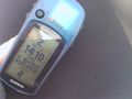
GPS

Panoramic Shot at the hash


Achievements
Nothing special.