Difference between revisions of "2012-01-12 59 18"
imported>Cjk (→Photos) |
imported>Cjk (→Photos) |
||
| Line 36: | Line 36: | ||
Image:2012-01-12_59_18_20-46-33-500.jpg | me at geohash [http://www.openstreetmap.org/?lat=59.09973866&lon=18.10298838&zoom=16&layers=B000FTF @59.0997,18.1030] | Image:2012-01-12_59_18_20-46-33-500.jpg | me at geohash [http://www.openstreetmap.org/?lat=59.09973866&lon=18.10298838&zoom=16&layers=B000FTF @59.0997,18.1030] | ||
| − | Image:2012-01-12_59_18_22-17-51-089.jpg | Second in the series of obscure bands. Nisennenmondai! | + | Image:2012-01-12_59_18_22-17-51-089.jpg | Second in the series of obscure bands. [http://www.nisennenmondai.com/ Nisennenmondai!] |
Image:2012-01-12_59_18_22-18-42-149.jpg | And it was freezing cold. | Image:2012-01-12_59_18_22-18-42-149.jpg | And it was freezing cold. | ||
Revision as of 00:51, 13 January 2012

| Thu 12 Jan 2012 in 59,18: 59.0997754, 18.1030507 geohashing.info google osm bing/os kml crox |
Location
The geohash seemed to be in a field fairly close to a tiny road in Västerhaninge.
Participants
Expedition
I got my Galaxy Nexus today so I needed to try out the Geohash Droid app of course.
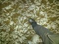
I drove off the motorway and onto the tiny road off Nynäsvägen. But it turns out that that road leads to Fors Reningsverk, a waste water treatment plant, and the gate was closed. The sign just says when they lock the gate, and you can walk past it if you like. It was pitch dark, ice road, the field had been plowed so it was really hard to walk on. Found the very featureless Geohash. Took some pictures, started freezing and ran back to the car.
Photos
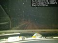
Icy road in the woods
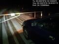
End of line for the car. That boom gets locked at 16:00.
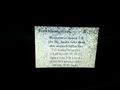
Yes, it's locked. Onwards on foot into the darkness.

me at geohash @59.0997,18.1030

Second in the series of obscure bands. Nisennenmondai!
And it was freezing cold.


Achievements