Difference between revisions of "2012-01-13 58 17"
imported>Cjk |
imported>Cjk |
||
| Line 1: | Line 1: | ||
| − | |||
[[Image:{{{image|2012-01-13_58_17_11-56-48-444.jpg}}}|thumb|left]] | [[Image:{{{image|2012-01-13_58_17_11-56-48-444.jpg}}}|thumb|left]] | ||
| Line 48: | Line 47: | ||
Image:2012-01-13_58_17_11-47-06-712.jpg | Field [http://www.openstreetmap.org/?lat=58.92892205&lon=17.83863740&zoom=16&layers=B000FTF @58.9289,17.8386] | Image:2012-01-13_58_17_11-47-06-712.jpg | Field [http://www.openstreetmap.org/?lat=58.92892205&lon=17.83863740&zoom=16&layers=B000FTF @58.9289,17.8386] | ||
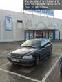
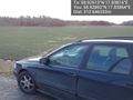
| − | Image:2012-01-13_58_17_11-56-48-444.jpg | Me with grin, | + | Image:2012-01-13_58_17_11-56-48-444.jpg | Me with grin, [http://deathfromabove1979.com/ Death from Above 1979] [http://www.openstreetmap.org/?lat=58.92646318&lon=17.83794288&zoom=16&layers=B000FTF @58.9265,17.8379] |
</gallery> | </gallery> | ||
| Line 58: | Line 57: | ||
<!-- =============== USEFUL CATEGORIES FOLLOW ================ | <!-- =============== USEFUL CATEGORIES FOLLOW ================ | ||
Delete the next line ONLY if you have chosen the appropriate categories below. If you are unsure, don't worry. People will read your report and help you with the classification. --> | Delete the next line ONLY if you have chosen the appropriate categories below. If you are unsure, don't worry. People will read your report and help you with the classification. --> | ||
| − | |||
<!-- Potential categories. Please include all the ones appropriate to your expedition --> | <!-- Potential categories. Please include all the ones appropriate to your expedition --> | ||
| Line 72: | Line 70: | ||
[[Category:Expedition without GPS]] | [[Category:Expedition without GPS]] | ||
--> | --> | ||
| + | [[Category:Expeditions]] | ||
| + | [[Category:Expeditions with photos]] | ||
| − | + | ||
[[Category:Coordinates reached]] | [[Category:Coordinates reached]] | ||
| − | + | ||
<!-- or if you failed :( | <!-- or if you failed :( | ||
Revision as of 12:23, 14 January 2012

| Fri 13 Jan 2012 in 58,17: 58.9261262, 17.8381610 geohashing.info google osm bing/os kml crox |
Location
In a frozen field of planted short grass.
Participants
Plans
The plan was to do a multihash, of the 6 closest graticules to Stockholm, Sweden. For once the Nynäshamn geohash was not in the Baltic ocean and the Norrköping one was close to Stockholm, and while I already was driving might as well do one more west, then go north and try to do 3 on the way back, Fagersta, Sala and east of Arlanda airport.
Expedition
Got into the car and drove south. Stopped for gas first since the plan was to do more than 600 km. Then south on the 73 towards Nynäshamn. I stopped at Biltema to get a car lighter splitter and a usb outlet for 12V so I could have the phone plugged in and on all the time. Also got a flashlight.
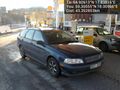
Onwards towards Nynäshamn and then take a right at the correct exit. Found the field, which was frozen and very featureless took some pictures but I had nothing to mark with. Should have bought some paint or something.
Then onto the next geohash!
Tracklog
Photos
Start of drive @59.3230,17.9896
Gas @59.3055,18.0097
Biltena @59.1803,18.1610
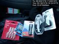
Stuff bought @59.1807,18.1610
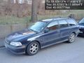
Field @58.9289,17.8386

Me with grin, Death from Above 1979 @58.9265,17.8379


Achievements