Difference between revisions of "2012-02-03 48 9"
imported>Steingesicht (→Achievements) |
imported>Jiml m (Add Ribbon and fix result codes) |
||
| Line 1: | Line 1: | ||
| − | |||
<!-- If you did not specify these parameters in the template, please substitute appropriate values for IMAGE, LAT, LON, and DATE (YYYY-MM-DD format) | <!-- If you did not specify these parameters in the template, please substitute appropriate values for IMAGE, LAT, LON, and DATE (YYYY-MM-DD format) | ||
| Line 15: | Line 14: | ||
}} | }} | ||
| − | + | ||
__NOTOC__ | __NOTOC__ | ||
== Location == | == Location == | ||
| − | + | ||
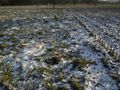
A field at a small suburb of Nürtingen city. | A field at a small suburb of Nürtingen city. | ||
== Participants == | == Participants == | ||
| − | + | ||
[[user:Steingesicht | Steingesicht]] was there in the afternoon around 16:00 | [[user:Steingesicht | Steingesicht]] was there in the afternoon around 16:00 | ||
== Plans == | == Plans == | ||
| − | + | ||
I had no special plans, since this geohash looked very easy. | I had no special plans, since this geohash looked very easy. | ||
== Expedition == | == Expedition == | ||
| − | + | ||
Weather today: Sunny sky, dry air, -14°C up to -10°C - cold, but not too cold for a winter day in middle europe. | Weather today: Sunny sky, dry air, -14°C up to -10°C - cold, but not too cold for a winter day in middle europe. | ||
Was there after work at my way home. | Was there after work at my way home. | ||
| + | |||
I parked my car at the road and walked some meters to the hashpoint. Thanks to the cold weather it was easy to step on the field (the soil was well frozen). | I parked my car at the road and walked some meters to the hashpoint. Thanks to the cold weather it was easy to step on the field (the soil was well frozen). | ||
| + | |||
Took some pictures (see below). | Took some pictures (see below). | ||
| + | |||
And after that I visited a really cool geocache and went home. | And after that I visited a really cool geocache and went home. | ||
== Tracklog == | == Tracklog == | ||
| − | + | ||
| − | no tracklog, but I will share my | + | no tracklog, but I will share my data with [http://www.openstreetmap.org | OSM] |
== Photos == | == Photos == | ||
| − | + | ||
| − | |||
| − | |||
<gallery perrow="5"> | <gallery perrow="5"> | ||
Image:2012 02 03 48 9-view.jpeg | View from hashpoint | Image:2012 02 03 48 9-view.jpeg | View from hashpoint | ||
| Line 68: | Line 68: | ||
}} | }} | ||
| + | {{Land geohash | ||
| − | + | | latitude = 48 | |
| − | + | | longitude = 9 | |
| − | + | | date = 2012-02-03 | |
| + | | name = Steingesicht | ||
| + | }} | ||
| − | + | ||
| − | + | ||
| − | [[Category: | + | [[Category:Expeditions]] |
| − | |||
[[Category:Expeditions with photos]] | [[Category:Expeditions with photos]] | ||
[[Category:Coordinates reached]] | [[Category:Coordinates reached]] | ||
| − | |||
| − | |||
| − | |||
| − | |||
| − | |||
| − | |||
| − | |||
| − | |||
| − | |||
| − | |||
Revision as of 01:18, 28 June 2012
| Fri 3 Feb 2012 in 48,9: 48.6130306, 9.3353587 geohashing.info google osm bing/os kml crox |
Location
A field at a small suburb of Nürtingen city.
Participants
Steingesicht was there in the afternoon around 16:00
Plans
I had no special plans, since this geohash looked very easy.
Expedition
Weather today: Sunny sky, dry air, -14°C up to -10°C - cold, but not too cold for a winter day in middle europe. Was there after work at my way home.
I parked my car at the road and walked some meters to the hashpoint. Thanks to the cold weather it was easy to step on the field (the soil was well frozen).
Took some pictures (see below).
And after that I visited a really cool geocache and went home.
Tracklog
no tracklog, but I will share my data with | OSM
Photos
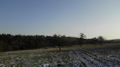
View from hashpoint
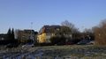
some residential buildings
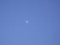
really clear sky
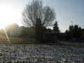
A small barn near the hashpoint
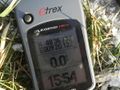
Proof
The Hashpoint
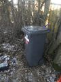
The really big box of the nearby geocache.
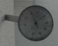
Later, back home I found a thermometer to make the temperature-proof picture.


Achievements
Steingesicht earned the Frozen Geohash Achievement
|
Steingesicht earned the Land geohash achievement
|