Difference between revisions of "2012-02-08 33 -117"
From Geohashing
imported>Scerruti m (→Photos) |
imported>Scerruti m (→Achievements) |
||
| Line 52: | Line 52: | ||
{{#vardefine:ribbonwidth|800px}} | {{#vardefine:ribbonwidth|800px}} | ||
<!-- Add any achievement ribbons you earned below, or remove this section --> | <!-- Add any achievement ribbons you earned below, or remove this section --> | ||
| + | {{land geohash | ||
| + | | latitude = 33 | ||
| + | | longitude = -117 | ||
| + | | date = date 2012-02-08 | ||
| + | | name = scerruti | ||
| + | | image = 2012-02-08_33_-117_08-31-01-859.jpg | ||
| + | |||
| + | }} | ||
<!-- =============== USEFUL CATEGORIES FOLLOW ================ | <!-- =============== USEFUL CATEGORIES FOLLOW ================ | ||
Revision as of 19:55, 8 February 2012
| Wed 8 Feb 2012 in 33,-117: 33.0425578, -117.2696880 geohashing.info google osm bing/os kml crox |
Location
In a driveway in Encinitas near my son's school.
Participants
Plans
- I may hit this hashpoint before I get coffee. -- Scerruti 06:55, 08 February 2012 (PST)
Expedition
- Nothing to see here, move along. -- Scerruti @33.0427,-117.2696 08:29, 08 February 2012 (PST)
Tracklog
Photos

Remember to smile. @33.0425,-117.2700
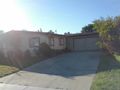
The lovely house at the hashpoint.
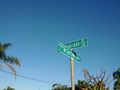
The street sign at the corner.


Achievements
scerruti earned the Land geohash achievement
|