Difference between revisions of "2012-02-16 59 18"
imported>Cjk |
imported>Cjk |
||
| Line 10: | Line 10: | ||
== Location == | == Location == | ||
<!-- where you've surveyed the hash to be --> | <!-- where you've surveyed the hash to be --> | ||
| − | At the far end of | + | At the far end of Österhaninge Gun Club's firing range, really close to the main gravel butt. |
== Participants == | == Participants == | ||
<!-- who attended --> | <!-- who attended --> | ||
| + | *[[User:Cjk|Carl-Johan]] | ||
| + | *[[User:TheDoctor|TheDoctor]] | ||
== Plans == | == Plans == | ||
<!-- what were the original plans --> | <!-- what were the original plans --> | ||
| + | Carl-Johan and TheDoctor had planned to meet anyway to discuss future plans and the hash today happened to fall just 14 km south of TheDoctor's home so a little roadtrip was in order. | ||
== Expedition == | == Expedition == | ||
<!-- how it all turned out. your narrative goes here. --> | <!-- how it all turned out. your narrative goes here. --> | ||
| + | Carl-Johan picked up his car and drove down and picked up TheDoctor after the sun had set. Some traffic on the main roads but nothing serious. We stopped briefly in Trångsund's center and went on the highway south towards Nynäshamn. Took the right exit and Carl-Johan had scoped beforehand that the has was just off the 227 also called Dalarövägen. As we got closer we looked on the left for the tiny road that would lead us to the hash. | ||
| + | [[Image:2012-02-16_59_18_21-50-52-295.jpg|200px]] | ||
| + | |||
| + | But as soon as we turned into it we were stopped by a really heavy boom, and no real signage saying why this road was closed. We parked the car in the snow and continued on foot. As we got to the field we realized where we were. | ||
| + | |||
| + | [[Image:2012-02-16_59_18_18-47-09-278.jpg|200px]] | ||
| + | |||
| + | The "field" was actually the firing range of Österhaninge Gun Club. It was really dark already and we could see the point were they usually fire from and there was no one around so we figured that it was probably safe to walk onto the range, so we did. We could see a lot of tracks in the snow so people had been here shooting fairly recently, probably earlier in the day. We walked down range over some mounds and at each mound there was a table and some wooden sofas and a metal trash can, and the trashcans were of course riddled with bullet holes. Since we started off on foot TheDoctor was now holding the GPS and he was concentrated on finding the hash so no pictures of the trashcans. Over the whole range we walked in about 20 cm of snow. | ||
| + | |||
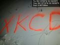
| + | As got to the far end of the range, just by the gravel butt that stops the bullets we were getting really close to the has and we found it easily and got within 0.2 m from it. As usual the hash was marked with Orange<sup>tm</sup> and we snapped some pics. We snapped some pics and started uploading them as we heard a lot of gun firing in the distance. Hunters? Maybe a lit up firing range some distance away. | ||
| + | |||
| + | *We are in the middle of a firing range -- [[User:Cjk|Carl-Johan]] [http://www.openstreetmap.org/?lat=59.13705690&lon=18.19228716&zoom=16&layers=B000FTF @59.1371,18.1923] 18:43, 16 February 2012 (CET) | ||
| + | |||
| + | We did have an IR meter with us to get the temperature but it was way off, probably not designed for frozen temperatures. It was -0 C in the car but we can't say what it was at the actual hash. | ||
| + | |||
| + | We started walking to the tiny road we had seen on google maps before and it turns out that the hash was just 20 m from it. Back to the car and back to TheDoctor's place for some tea and a nice dinner. | ||
| − | |||
== Tracklog == | == Tracklog == | ||
<!-- if your GPS device keeps a log, you may post a link here --> | <!-- if your GPS device keeps a log, you may post a link here --> | ||
| + | [http://maps.google.com/maps/ms?msa=0&msid=209560846421673743077.0004b91b062d2d82359cc tracklog for the trip] | ||
== Photos == | == Photos == | ||
| Line 42: | Line 61: | ||
Image:2012-02-16_59_18_18-46-43-143.jpg | Marker [http://www.openstreetmap.org/?lat=59.13710000&lon=18.19230000&zoom=16&layers=B000FTF @59.1371,18.1923] | Image:2012-02-16_59_18_18-46-43-143.jpg | Marker [http://www.openstreetmap.org/?lat=59.13710000&lon=18.19230000&zoom=16&layers=B000FTF @59.1371,18.1923] | ||
| − | Image:2012-02-16_59_18_18-49-20-422.jpg | | + | Image:2012-02-16_59_18_18-49-20-422.jpg | The hash is just 21 m behind this warning sign inside the range. [http://www.openstreetmap.org/?lat=59.13710000&lon=18.19190000&zoom=16&layers=B000FTF @59.1371,18.1919] |
</gallery> | </gallery> | ||
| Line 48: | Line 67: | ||
{{#vardefine:ribbonwidth|800px}} | {{#vardefine:ribbonwidth|800px}} | ||
<!-- Add any achievement ribbons you earned below, or remove this section --> | <!-- Add any achievement ribbons you earned below, or remove this section --> | ||
| + | {{Land geohash | latitude = 59 | longitude = 18 | date = 2012-02-16 | name = [[User:Cjk|Carl-Johan]] and [[User:TheDoctor|TheDoctor]] | image = 2012-02-16_59_18_18-46-18-575.jpg }} | ||
| + | {{drag-along | latitude = 59 | longitude = 18 | date = 2012-02-16 | name = [[User:Cjk|Carl-Johan]] | partner = [[User:TheDoctor|TheDoctor]] | image = 2012-02-16_59_18_18-45-34-315.jpg }} | ||
<!-- =============== USEFUL CATEGORIES FOLLOW ================ | <!-- =============== USEFUL CATEGORIES FOLLOW ================ | ||
Delete the next line ONLY if you have chosen the appropriate categories below. If you are unsure, don't worry. People will read your report and help you with the classification. --> | Delete the next line ONLY if you have chosen the appropriate categories below. If you are unsure, don't worry. People will read your report and help you with the classification. --> | ||
| − | |||
| − | |||
| − | |||
| − | |||
| − | |||
| − | |||
| − | |||
| − | |||
[[Category:Expeditions]] | [[Category:Expeditions]] | ||
| − | |||
[[Category:Expeditions with photos]] | [[Category:Expeditions with photos]] | ||
| − | |||
| − | |||
| − | |||
| − | |||
| − | |||
[[Category:Coordinates reached]] | [[Category:Coordinates reached]] | ||
| − | |||
| − | |||
| − | |||
| − | |||
| − | |||
| − | |||
| − | |||
| − | |||
| − | |||
| − | |||
Revision as of 21:35, 16 February 2012

| Thu 16 Feb 2012 in 59,18: 59.1370548, 18.1922868 geohashing.info google osm bing/os kml crox |
Location
At the far end of Österhaninge Gun Club's firing range, really close to the main gravel butt.
Participants
Plans
Carl-Johan and TheDoctor had planned to meet anyway to discuss future plans and the hash today happened to fall just 14 km south of TheDoctor's home so a little roadtrip was in order.
Expedition
Carl-Johan picked up his car and drove down and picked up TheDoctor after the sun had set. Some traffic on the main roads but nothing serious. We stopped briefly in Trångsund's center and went on the highway south towards Nynäshamn. Took the right exit and Carl-Johan had scoped beforehand that the has was just off the 227 also called Dalarövägen. As we got closer we looked on the left for the tiny road that would lead us to the hash.

But as soon as we turned into it we were stopped by a really heavy boom, and no real signage saying why this road was closed. We parked the car in the snow and continued on foot. As we got to the field we realized where we were.

The "field" was actually the firing range of Österhaninge Gun Club. It was really dark already and we could see the point were they usually fire from and there was no one around so we figured that it was probably safe to walk onto the range, so we did. We could see a lot of tracks in the snow so people had been here shooting fairly recently, probably earlier in the day. We walked down range over some mounds and at each mound there was a table and some wooden sofas and a metal trash can, and the trashcans were of course riddled with bullet holes. Since we started off on foot TheDoctor was now holding the GPS and he was concentrated on finding the hash so no pictures of the trashcans. Over the whole range we walked in about 20 cm of snow.
As got to the far end of the range, just by the gravel butt that stops the bullets we were getting really close to the has and we found it easily and got within 0.2 m from it. As usual the hash was marked with Orangetm and we snapped some pics. We snapped some pics and started uploading them as we heard a lot of gun firing in the distance. Hunters? Maybe a lit up firing range some distance away.
- We are in the middle of a firing range -- Carl-Johan @59.1371,18.1923 18:43, 16 February 2012 (CET)
We did have an IR meter with us to get the temperature but it was way off, probably not designed for frozen temperatures. It was -0 C in the car but we can't say what it was at the actual hash.
We started walking to the tiny road we had seen on google maps before and it turns out that the hash was just 20 m from it. Back to the car and back to TheDoctor's place for some tea and a nice dinner.
Tracklog
Photos
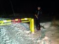
Why this heavy boom here?
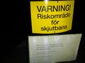
Danger!
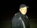
TheDoctor with guns firing in the distance @59.1371,18.1923
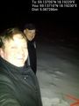
Carl-Johan and TheDoctor @59.1371,18.1923
Marker @59.1371,18.1923
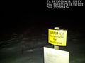
The hash is just 21 m behind this warning sign inside the range. @59.1371,18.1919


Achievements
Carl-Johan and TheDoctor earned the Land geohash achievement
|
Carl-Johan earned the Drag-along achievement
|