Difference between revisions of "2012-02-21 -38 145"
From Geohashing
imported>Felix Dance (Created Page) |
imported>Felix Dance (Added expedition images) |
||
| Line 15: | Line 15: | ||
| − | [ Here] is the | + | [http://g.co/maps/xbmp7 Here] is the Google Maps route we took. |
| − | |||
== Photos == | == Photos == | ||
| − | <gallery perrow=" | + | <gallery perrow="8"> |
| − | Image: | + | Image:Geohash 2012 02 21 -38 145 Track.JPG|Track to the geohash |
| + | Image:Geohash 2012 02 21 -38 145 Sunset.JPG|Sunset | ||
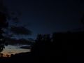
| + | Image:Geohash 2012 02 21 -38 145 GPS.JPG|GPS proof | ||
| + | Image:Geohash 2012 02 21 -38 145 Picnic.JPG|Geohash picnic | ||
| + | Image:Geohash 2012 02 21 -38 145 Group.JPG|Mandatory group shot | ||
| + | Image:Geohash 2012 02 21 -38 145 Beer.JPG|Post-dinner beer | ||
| + | Image:Geohash 2012 02 21 -38 145 Sky.JPG|Night sky with Venus and Jupiter | ||
| + | Image:Geohash 2012 02 21 -38 145 Spider.JPG|St Andrews Cross spider barring our return | ||
</gallery> | </gallery> | ||
| − | |||
== Achievements == | == Achievements == | ||
Revision as of 20:34, 21 February 2012
| Tue 21 Feb 2012 in -38,145: -38.7808811, 145.8922065 geohashing.info google osm bing/os kml crox |
Location
In a field near the beach at Cape Liptrap.
Who went
- Felix Dance, Haydn, Joel and Frenchie from the Victorian Desalination Project.
Expedition
Felix Dance
Here is the Google Maps route we took.
Photos
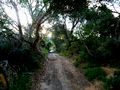
Track to the geohash
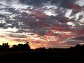
Sunset
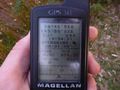
GPS proof
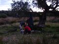
Geohash picnic
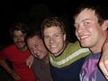
Mandatory group shot
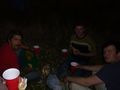
Post-dinner beer
Night sky with Venus and Jupiter
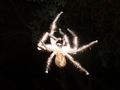
St Andrews Cross spider barring our return


