Difference between revisions of "2012-02-29 50 10"
imported>Cjk |
imported>Mampfred m |
||
| Line 1: | Line 1: | ||
| − | |||
| − | |||
| − | |||
| − | |||
| − | |||
| − | |||
| − | |||
| − | |||
| − | |||
{{meetup graticule | {{meetup graticule | ||
| lat=50 | | lat=50 | ||
| Line 14: | Line 5: | ||
}} | }} | ||
| − | |||
__NOTOC__ | __NOTOC__ | ||
== Location == | == Location == | ||
| − | + | In the woods near Schmalkalden. | |
== Participants == | == Participants == | ||
| − | + | * [[User:Rincewind|Rincewind]] | |
| + | * [[User:Mampfred|Mampfred]] | ||
== Plans == | == Plans == | ||
| − | + | Leap there after work, it'll be a long drive but what else would we do after work ... right? | |
== Expedition == | == Expedition == | ||
| − | + | Seriously. Who decided to spontaneuosly invent a new achievement that can only be claimed every four year? We obviously couldn't miss that so Mampfred stayed a day longer in Erfurt than planned and we made plans to head out after work that day. | |
| + | |||
| + | *Mampfred and Rincewind are on the way :) -- [[User:Mampfred|Mampfred]] [http://www.openstreetmap.org/?lat=51.01711220&lon=10.98268100&zoom=16&layers=B000FTF @51.0171,10.9827] 13:59, 29 February 2012 (EST) | ||
| + | |||
| + | After a quick stop at a well known restaurant with the big golden M for a milkshake and a McDouble we started the one hour drive to the hash. To be honest, we usually tend to pass on hashes that far away so this definitely is an exceptional expedition ;) | ||
| + | |||
| + | Thankfully Mampfred had decided to ignore the address that Geohashdroid in combination with Google Maps had suggested and picked a spot at the entrance to a little valley to park the car (good planning is everything). | ||
| + | |||
| + | From there, a little track ascended along the mountains, crossing a little stream multiple times on it's way up. The hashers quickly realized that the recent general rise of temperatures hadn't reached this area yet as they encountered steaply dropping temperatures, lots of snow and very icy patches on the track they moved on. So much for the good preparation ... we didn't excpect that. | ||
| + | |||
| + | A hundred meters away from the hash the track started rising even more quickly while the little stream dropped off to the left. Bummer, as the hash seemed to be to our left as well. Just as the hashers started debating whether to turn back and follow the stream in the valley instead, a little miracle happened: to the eft behind some trees a natural bridge appeared leading almost straight in the direction of the hash and allowing the hashers to continue :) | ||
| + | |||
| + | After crossing the brigde it was only a matter of climbing a good 30 meters of hillside with lots of trees and a good 60cm of snow at times => that's were the leaping came in :D | ||
| + | |||
| + | GPS dancing in those conditions is a lot less fun than it sounds but we eventually found the spot and quickly shot some stupid grins while all the snow in our shoes started melting. | ||
| + | The way back was a lot more relaxed and uneventful which includes the drive back home. | ||
| − | |||
== Tracklog == | == Tracklog == | ||
| − | + | TODO | |
== Photos == | == Photos == | ||
| − | + | TODO | |
| − | |||
| − | |||
<gallery perrow="5"> | <gallery perrow="5"> | ||
| − | |||
Image:2012-02-29_50_10_21-43-22-216.jpg | Coordinates reached. Shoes full of snow. Unexpected :) | Image:2012-02-29_50_10_21-43-22-216.jpg | Coordinates reached. Shoes full of snow. Unexpected :) | ||
</gallery> | </gallery> | ||
| Line 44: | Line 46: | ||
== Achievements == | == Achievements == | ||
{{#vardefine:ribbonwidth|800px}} | {{#vardefine:ribbonwidth|800px}} | ||
| − | + | {{Leap geohash | |
| − | + | | year = 2012 | |
| − | + | | lat = 50 | |
| − | + | | lon = 10 | |
| − | + | | name = [[User:Mampfred|Mampfred]] and [[User:Rincewind|Rincewind]] | |
| − | [[ | + | }} |
| + | * Land | ||
| − | |||
| − | |||
| − | |||
| − | |||
| − | |||
| − | |||
| − | |||
| − | |||
| − | |||
| − | |||
| − | |||
| − | |||
| − | |||
| − | |||
| − | |||
[[Category:Expeditions]] | [[Category:Expeditions]] | ||
[[Category:Expeditions with photos]] | [[Category:Expeditions with photos]] | ||
| − | + | [[Category:Coordinates reached]] | |
| − | [[Category:Coordinates | ||
| − | |||
| − | |||
| − | |||
| − | |||
| − | |||
| − | |||
Revision as of 08:52, 1 March 2012
| Wed 29 Feb 2012 in 50,10: 50.7230499, 10.5646499 geohashing.info google osm bing/os kml crox |
Location
In the woods near Schmalkalden.
Participants
Plans
Leap there after work, it'll be a long drive but what else would we do after work ... right?
Expedition
Seriously. Who decided to spontaneuosly invent a new achievement that can only be claimed every four year? We obviously couldn't miss that so Mampfred stayed a day longer in Erfurt than planned and we made plans to head out after work that day.
- Mampfred and Rincewind are on the way :) -- Mampfred @51.0171,10.9827 13:59, 29 February 2012 (EST)
After a quick stop at a well known restaurant with the big golden M for a milkshake and a McDouble we started the one hour drive to the hash. To be honest, we usually tend to pass on hashes that far away so this definitely is an exceptional expedition ;)
Thankfully Mampfred had decided to ignore the address that Geohashdroid in combination with Google Maps had suggested and picked a spot at the entrance to a little valley to park the car (good planning is everything).
From there, a little track ascended along the mountains, crossing a little stream multiple times on it's way up. The hashers quickly realized that the recent general rise of temperatures hadn't reached this area yet as they encountered steaply dropping temperatures, lots of snow and very icy patches on the track they moved on. So much for the good preparation ... we didn't excpect that.
A hundred meters away from the hash the track started rising even more quickly while the little stream dropped off to the left. Bummer, as the hash seemed to be to our left as well. Just as the hashers started debating whether to turn back and follow the stream in the valley instead, a little miracle happened: to the eft behind some trees a natural bridge appeared leading almost straight in the direction of the hash and allowing the hashers to continue :)
After crossing the brigde it was only a matter of climbing a good 30 meters of hillside with lots of trees and a good 60cm of snow at times => that's were the leaping came in :D
GPS dancing in those conditions is a lot less fun than it sounds but we eventually found the spot and quickly shot some stupid grins while all the snow in our shoes started melting.
The way back was a lot more relaxed and uneventful which includes the drive back home.
Tracklog
TODO
Photos
TODO
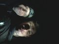
Coordinates reached. Shoes full of snow. Unexpected :)

Achievements
Mampfred and Rincewind earned the Leap geohash achievement 2012
|
- Land