Difference between revisions of "2012-02-29 30 -94"
From Geohashing
imported>Lnettnay (→Photos) |
imported>Jiml m (Adjust result codes) |
||
| Line 1: | Line 1: | ||
| − | |||
<!-- If you did not specify these parameters in the template, please substitute appropriate values for IMAGE, LAT, LON, and DATE (YYYY-MM-DD format) | <!-- If you did not specify these parameters in the template, please substitute appropriate values for IMAGE, LAT, LON, and DATE (YYYY-MM-DD format) | ||
| Line 27: | Line 26: | ||
== Expedition == | == Expedition == | ||
| + | |||
Drove up and wandered around trying to reach the hashpoint. A lady who was burning trash came by in her golf cart to see if I needed any help and I tried to explain what I was doing. I got a ''weird'' look from her. The hashpoint was in the woods and I wasn't prepared to enter them. | Drove up and wandered around trying to reach the hashpoint. A lady who was burning trash came by in her golf cart to see if I needed any help and I tried to explain what I was doing. I got a ''weird'' look from her. The hashpoint was in the woods and I wasn't prepared to enter them. | ||
| − | |||
| − | |||
== Photos == | == Photos == | ||
| − | + | ||
| − | |||
| − | |||
<gallery perrow="5">Image:2012-02-29_geohash.jpg | Wasn't ready for the woods | <gallery perrow="5">Image:2012-02-29_geohash.jpg | Wasn't ready for the woods | ||
</gallery> | </gallery> | ||
| Line 51: | Line 47: | ||
| expedition = [[2012-02-29 30 -94]] | | expedition = [[2012-02-29 30 -94]] | ||
}}<noinclude> | }}<noinclude> | ||
| + | |||
| + | * Mother Nature? | ||
| − | |||
| − | |||
| − | |||
| − | |||
| − | |||
| − | |||
| − | |||
| − | |||
[[Category:Expeditions]] | [[Category:Expeditions]] | ||
| − | + | ||
[[Category:Expeditions with photos]] | [[Category:Expeditions with photos]] | ||
| − | |||
| − | |||
| − | |||
| − | |||
| − | |||
| − | |||
| − | + | ||
| + | |||
[[Category:Coordinates not reached]] | [[Category:Coordinates not reached]] | ||
| − | + | ||
| − | [[Category:Not reached - Mother Nature]] | + | [[Category:Not reached - Mother Nature]] |
| − | |||
| − | |||
| − | |||
| − | |||
Revision as of 01:41, 28 June 2012
| Wed 29 Feb 2012 in 30,-94: 30.3129303, -94.1794689 geohashing.info google osm bing/os kml crox |
Location
Friendship Road in Silsbee, Tx
Participants
Plans
The hashpoint was right off a main road so I just planned to drive up there and walk the rest off the way.
Expedition
Drove up and wandered around trying to reach the hashpoint. A lady who was burning trash came by in her golf cart to see if I needed any help and I tried to explain what I was doing. I got a weird look from her. The hashpoint was in the woods and I wasn't prepared to enter them.
Photos
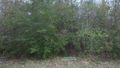
Wasn't ready for the woods

Achievements
This user earned the Leap geohash achievement 2012
|
- Mother Nature?