Difference between revisions of "2012-03-20 48 11"
From Geohashing
imported>Jcbck (→Participants) |
imported>Mampfred m (cleanup) |
||
| Line 1: | Line 1: | ||
| − | |||
| − | |||
| − | |||
| − | |||
| − | |||
| − | |||
| − | |||
| − | |||
| − | |||
{{meetup graticule | {{meetup graticule | ||
| lat=48 | | lat=48 | ||
| Line 15: | Line 6: | ||
}} | }} | ||
| − | |||
__NOTOC__ | __NOTOC__ | ||
== Location == | == Location == | ||
| − | |||
4m into a field from the forest northern boundary | 4m into a field from the forest northern boundary | ||
== Participants == | == Participants == | ||
| − | |||
*[[User:Jcbck|Jcbck]] | *[[User:Jcbck|Jcbck]] | ||
| Line 29: | Line 17: | ||
== Expedition == | == Expedition == | ||
| − | |||
I had something to do in the area anyway, so I took a look at todays hash location. It's app. 4m into a field from the north boundary of a small forest stripe. The field and the forest are separated by a small drain. The nearest track runs along the southern end of the forest, so I had to cross it without a path. Fortunately it was not very dense, so no problem there. The location is an unspectacular but still nice place. | I had something to do in the area anyway, so I took a look at todays hash location. It's app. 4m into a field from the north boundary of a small forest stripe. The field and the forest are separated by a small drain. The nearest track runs along the southern end of the forest, so I had to cross it without a path. Fortunately it was not very dense, so no problem there. The location is an unspectacular but still nice place. | ||
| Line 36: | Line 23: | ||
== Photos == | == Photos == | ||
| − | |||
| − | |||
| − | |||
<gallery perrow="5"> | <gallery perrow="5"> | ||
Image:20120320_48_11-1.jpg | Almost there | Image:20120320_48_11-1.jpg | Almost there | ||
| Line 48: | Line 32: | ||
== Achievements == | == Achievements == | ||
{{#vardefine:ribbonwidth|800px}} | {{#vardefine:ribbonwidth|800px}} | ||
| − | + | * Land | |
| − | |||
| − | |||
| − | |||
| − | |||
| − | |||
| − | |||
| − | |||
| − | |||
| − | |||
| − | |||
| − | |||
[[Category:Expeditions]] | [[Category:Expeditions]] | ||
| − | |||
[[Category:Expeditions with photos]] | [[Category:Expeditions with photos]] | ||
| − | |||
| − | |||
| − | |||
| − | |||
| − | |||
[[Category:Coordinates reached]] | [[Category:Coordinates reached]] | ||
| − | |||
| − | |||
| − | |||
| − | |||
| − | |||
| − | |||
| − | |||
| − | |||
| − | |||
| − | |||
Revision as of 17:40, 20 March 2012
| Tue 20 Mar 2012 in 48,11: 48.4478887, 11.4070098 geohashing.info google osm bing/os kml crox |
Location
4m into a field from the forest northern boundary
Participants
Plans
Expedition
I had something to do in the area anyway, so I took a look at todays hash location. It's app. 4m into a field from the north boundary of a small forest stripe. The field and the forest are separated by a small drain. The nearest track runs along the southern end of the forest, so I had to cross it without a path. Fortunately it was not very dense, so no problem there. The location is an unspectacular but still nice place.
Tracklog
Photos
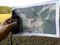
Almost there
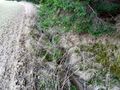
the drain that separates the field from the forest
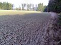
the view roughly west
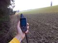
the view roughly east


Achievements
- Land