Difference between revisions of "2012-03-26 41 -80"
imported>Jiml m (Expand Template) |
imported>Jiml m (Move details around) |
||
| Line 1: | Line 1: | ||
| − | |||
<!-- If you did not specify these parameters in the template, please substitute appropriate values for IMAGE, LAT, LON, and DATE (YYYY-MM-DD format) | <!-- If you did not specify these parameters in the template, please substitute appropriate values for IMAGE, LAT, LON, and DATE (YYYY-MM-DD format) | ||
| Line 15: | Line 14: | ||
}} | }} | ||
| − | + | ||
__NOTOC__ | __NOTOC__ | ||
== Location == | == Location == | ||
<!-- where you've surveyed the hash to be --> | <!-- where you've surveyed the hash to be --> | ||
| + | |||
| + | Near Grove City | ||
== Participants == | == Participants == | ||
<!-- who attended --> | <!-- who attended --> | ||
| + | |||
| + | * [[User:Nsnyder|Nsnyder]] 21:41, 26 March 2012 (EDT) | ||
== Plans == | == Plans == | ||
| Line 28: | Line 31: | ||
== Expedition == | == Expedition == | ||
<!-- how it all turned out. your narrative goes here. --> | <!-- how it all turned out. your narrative goes here. --> | ||
| + | |||
| + | |||
| + | ===Operation Virgin Geohash=== | ||
| + | I set out, with only my running shoes and trusty Droid Incredible as my GPS, to be the first to claim a geohash in the Youngstown, Ohio location. As I set out, I ran along the road, climbed onto the train tracks, and approached my goal. I looked on in determination as it became apparent that I must cross a swamp in order to reach the location. Google maps had obscured this fact by showing me the woods. Still, I pressed on. I climbed down the hill and sloshed through the swamp, careful not to drop my Droid Incredible as I went. Finally, I crossed the large swamp and then a smaller marsh and reached the field. From then, it was only a matter of locating the location in the field. Embedded is the proof. I realize that I forgot the date, but rest assured, as I upload this on March 26, I have claimed the graticule. The first to claim Youngstown, Ohio! | ||
| + | |||
| + | (The distance to location is 2.78 meters, well within the margin of error for the GPS) | ||
| + | |||
| + | |||
| + | |||
| + | |||
== Tracklog == | == Tracklog == | ||
| Line 37: | Line 50: | ||
--> | --> | ||
<gallery perrow="5"> | <gallery perrow="5"> | ||
| + | Image:Screenshot_2012-03-26-16-53-35.png | GPS | ||
| + | Image:Nsnyder-2012-03-26.jpg | The Geohasher | ||
</gallery> | </gallery> | ||
| Line 43: | Line 58: | ||
<!-- Add any achievement ribbons you earned below, or remove this section --> | <!-- Add any achievement ribbons you earned below, or remove this section --> | ||
| + | * Land Geohash | ||
<!-- =============== USEFUL CATEGORIES FOLLOW ================ | <!-- =============== USEFUL CATEGORIES FOLLOW ================ | ||
| Line 48: | Line 64: | ||
[[Category:New report]] | [[Category:New report]] | ||
| − | |||
| − | |||
| − | |||
| − | |||
| − | |||
[[Category:Expeditions]] | [[Category:Expeditions]] | ||
| − | + | ||
[[Category:Expeditions with photos]] | [[Category:Expeditions with photos]] | ||
| − | |||
| − | |||
| − | |||
| − | |||
| − | |||
[[Category:Coordinates reached]] | [[Category:Coordinates reached]] | ||
| − | |||
| − | |||
| − | |||
| − | |||
| − | |||
| − | |||
| − | |||
| − | |||
| − | |||
| − | |||
| − | |||
| − | |||
| − | |||
| − | |||
| − | |||
| − | |||
| − | |||
| − | |||
| − | |||
| − | |||
| − | |||
| − | |||
| − | |||
| − | |||
| − | |||
| − | |||
| − | |||
| − | |||
| − | |||
| − | |||
| − | |||
| − | |||
| − | |||
Revision as of 07:17, 27 March 2012
| Mon 26 Mar 2012 in 41,-80: 41.1278934, -80.0496628 geohashing.info google osm bing/os kml crox |
Location
Near Grove City
Participants
- Nsnyder 21:41, 26 March 2012 (EDT)
Plans
Expedition
Operation Virgin Geohash
I set out, with only my running shoes and trusty Droid Incredible as my GPS, to be the first to claim a geohash in the Youngstown, Ohio location. As I set out, I ran along the road, climbed onto the train tracks, and approached my goal. I looked on in determination as it became apparent that I must cross a swamp in order to reach the location. Google maps had obscured this fact by showing me the woods. Still, I pressed on. I climbed down the hill and sloshed through the swamp, careful not to drop my Droid Incredible as I went. Finally, I crossed the large swamp and then a smaller marsh and reached the field. From then, it was only a matter of locating the location in the field. Embedded is the proof. I realize that I forgot the date, but rest assured, as I upload this on March 26, I have claimed the graticule. The first to claim Youngstown, Ohio!
(The distance to location is 2.78 meters, well within the margin of error for the GPS)
Tracklog
Photos
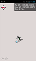
GPS
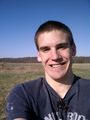
The Geohasher


Achievements
- Land Geohash