Difference between revisions of "2012-04-04 -35 149"
imported>1PE (details) |
imported>1PE (pics) |
||
| Line 1: | Line 1: | ||
<!-- If you did not specify these parameters in the template, please substitute appropriate values for IMAGE, LAT, LON, and DATE (YYYY-MM-DD format) | <!-- If you did not specify these parameters in the template, please substitute appropriate values for IMAGE, LAT, LON, and DATE (YYYY-MM-DD format) | ||
| − | + | ||
Remove this section if you don't want an image at the top (left) of your report. You should remove the "Image:" or "File:" | Remove this section if you don't want an image at the top (left) of your report. You should remove the "Image:" or "File:" | ||
| Line 8: | Line 8: | ||
And DON'T FORGET to add your expedition and the best photo you took to the gallery on the Main Page! We'd love to read your report, but that means we first have to discover it! | And DON'T FORGET to add your expedition and the best photo you took to the gallery on the Main Page! We'd love to read your report, but that means we first have to discover it! | ||
--> | --> | ||
| + | [[Image:{{{image|2012-04-04 -35 149A.JPG}}}|thumb|left]] | ||
{{meetup graticule | {{meetup graticule | ||
| lat=-35 | | lat=-35 | ||
| Line 45: | Line 46: | ||
== Photos == | == Photos == | ||
<!-- Insert pictures between the gallery tags using the following format: | <!-- Insert pictures between the gallery tags using the following format: | ||
| − | + | ||
--> | --> | ||
<gallery perrow="5"> | <gallery perrow="5"> | ||
| + | Image:2012-04-04 -35 149A.JPG | I am not a weed control expert. (See the owner at the gate.) | ||
| + | Image:2012-04-04 -35 149B.JPG | The really large log; Sutton Road in background. | ||
</gallery> | </gallery> | ||
Revision as of 08:14, 4 April 2012

| Wed 4 Apr 2012 in -35,149: -35.2402559, 149.2664080 geohashing.info google osm bing/os kml crox |
Location
Just off Sutton Road, Womboin, about 15km from Canberra.
Participants
Plans
1PE
Another lunchtime expedition; R/V at 12:45pm if possible.
The site is in a field just off Sutton Road. There is a house on the block. There appears to be a track on two other sides of the field, so the approach can be from three directions; probably safer from the tracks rather than parking on the side of Sutton road.
Expedition
1PE
I drove out along Sutton Road, and realised that it would be best to drive to the house and ask permission.I found the house number on the fence post beside the gate, having recognised the fallen tree in the field. I went to the house, which was shut and locked. I knocked, had no reply, and left a copy of the Active Geohasher poster.
I went back to the field, parked beside the track, and went through the gate that allows for servicing the high voltage powerline that crosses the field north-south. A short walk under the powerline led directly to the spot, between the tree and the dead tree's fallen log in a sheep paddock. (Sheep dung is distinctively shaped....) I got my pictures, and then realised that I had company.
There was a man at the gate coming to meet me. There was a car parked beside mine.
I apologised and explained geohashing, showing him the other copy of the ActiveGeohasher poster that I had intended to attach to the log. We had a conversation about it, and he explained that he had been expecting a weed control expert who had promised to come "in late March". I then got to walk back to our cars and briefly greet a woman sitting in their car; his sister. I thanked them and left.
I did not explore the tracks (mentioned above) that are visible on the overhead photography.
Tracklog
Photos
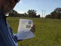
I am not a weed control expert. (See the owner at the gate.)
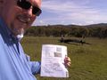
The really large log; Sutton Road in background.

Achievements