Difference between revisions of "2012-04-10 42 -4"
imported>Kydlt (→Plans) |
imported>Kydlt |
||
| Line 17: | Line 17: | ||
== Expedition == | == Expedition == | ||
| − | + | ||
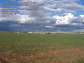
| + | The 10th was a long drive day, from Bilbao on the north (Atlantic) coast to Salamanca (200 Km W. of Madrid) down E-80/A-62. The hash appeared to be in a field not too far off the highway. Leaving the highway we crept through the edge of another medieval village, with waves and smiles. there was a road that took us back up toward the river, and let up pull up a couple 100 m away from the hash. Walking most of the way on a drainage ditch let us achieve the hash with a minimal walk across freshly plowed field. A lovely spot, with ruins near by, as in most of Spain. | ||
| + | |||
| + | |||
| + | We were challenged by lack of mapping, and lack of my trusty PN-20 GPS. So we were using the ipad GPS | ||
| + | with the Spain NavMii app for our driving guidance. It suffers from open source maps that are not | ||
| + | particularly good (for Spain, anyway). And Motion X's GPS HD for walking adventures. It can download | ||
| + | Bing or Goggle maps and/or imagery, but needs a wifi connection. often missing. Also loaded on the ipad | ||
| + | was Hunter Researches Theodolite, which geotags photos. when I remember to turn it on. | ||
== Tracklog == | == Tracklog == | ||
| Line 23: | Line 31: | ||
== Photos == | == Photos == | ||
| − | <gallery perrow=" | + | <gallery perrow="3"> |
| + | Image:2012-04-10 42 -4 01 hash exit.jpg|Getting off A62. | ||
| + | Image:2012-04-10 42 -4 02 rental car.jpg|Rental cars are great for driving down bad roads. | ||
| + | Image:2012-04-10 42 -4 03 Number 1 son.jpg|He thought the whole idea was wierd. But he was real excited once we got here. | ||
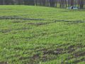
| + | Image:2012-04-10 42 -4 04 ruin.jpg | Everywhere you look, something old. | ||
| + | Image:2012-04-10 42 -4 05 oops.jpg | This was supose to be my 'proof' photo. but I had ledt the in app GPS switch off. Someday I will learn how to work my ipad. | ||
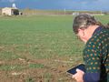
| + | Image:2012-04-10 42 -4 06 real near.jpg | Here is the GPS HD nav page. As you can see, it has drifted to "15 ft off", and has no coordinates displayed. But we really were here. Or there. Jeremy and I know we made it anyway. | ||
</gallery> | </gallery> | ||
| Line 32: | Line 46: | ||
{{Virgin graticule | {{Virgin graticule | ||
| − | + | | latitude = 42 | |
| + | | longitude = -4 | ||
| + | | date = 2012-04-10 | ||
| + | | name = kydlt | ||
}} | }} | ||
| + | If we were not the first in this graticle will someone please point that out. | ||
[[Category:Expeditions]] | [[Category:Expeditions]] | ||
[[Category:Expeditions with photos]] | [[Category:Expeditions with photos]] | ||
[[Category:Coordinates reached]] | [[Category:Coordinates reached]] | ||
| − | |||
| − | |||
Revision as of 18:14, 26 April 2012
| Tue 10 Apr 2012 in 42,-4: 42.1561587, -4.0656454 geohashing.info google osm bing/os kml crox |
Location
In a field in the village of Villaverde de Mogina.
Participants
And his son/navigator/non-hasher, jgt.
Plans
I was in Spain having an adventure with my eldest. It involved driving from Barcelona up to the Atlantic coast, and then south to the Med coasr, and back to Madrid. So many opportunities might present themselves.
Expedition
The 10th was a long drive day, from Bilbao on the north (Atlantic) coast to Salamanca (200 Km W. of Madrid) down E-80/A-62. The hash appeared to be in a field not too far off the highway. Leaving the highway we crept through the edge of another medieval village, with waves and smiles. there was a road that took us back up toward the river, and let up pull up a couple 100 m away from the hash. Walking most of the way on a drainage ditch let us achieve the hash with a minimal walk across freshly plowed field. A lovely spot, with ruins near by, as in most of Spain.
We were challenged by lack of mapping, and lack of my trusty PN-20 GPS. So we were using the ipad GPS
with the Spain NavMii app for our driving guidance. It suffers from open source maps that are not
particularly good (for Spain, anyway). And Motion X's GPS HD for walking adventures. It can download
Bing or Goggle maps and/or imagery, but needs a wifi connection. often missing. Also loaded on the ipad
was Hunter Researches Theodolite, which geotags photos. when I remember to turn it on.
Tracklog
== Photos ==
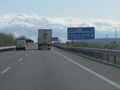
Getting off A62.
Rental cars are great for driving down bad roads.
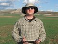
He thought the whole idea was wierd. But he was real excited once we got here.
Everywhere you look, something old.
This was supose to be my 'proof' photo. but I had ledt the in app GPS switch off. Someday I will learn how to work my ipad.
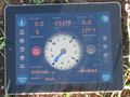
Here is the GPS HD nav page. As you can see, it has drifted to "15 ft off", and has no coordinates displayed. But we really were here. Or there. Jeremy and I know we made it anyway.


Achievements
Template:Virgin graticule If we were not the first in this graticle will someone please point that out.