Difference between revisions of "2012-05-07 52 13"
From Geohashing
imported>Jiml m (Result codes look right) |
imported>Eldin m (add ribbon) |
||
| Line 1: | Line 1: | ||
| − | |||
| − | |||
| − | |||
| − | |||
| − | |||
| − | |||
| − | |||
| − | |||
| − | |||
| − | |||
<!-- edit as necessary --> | <!-- edit as necessary --> | ||
__NOTOC__ | __NOTOC__ | ||
| Line 43: | Line 33: | ||
== Achievements == | == Achievements == | ||
{{#vardefine:ribbonwidth|800px}} | {{#vardefine:ribbonwidth|800px}} | ||
| − | + | {{land geohash | |
| − | + | | latitude = 52 | |
| − | + | | longitude = 13 | |
| + | | date = 2012-05-07 | ||
| + | | name = [[User:Kattapa|Kattapa]] | ||
| + | }} | ||
Revision as of 04:58, 17 May 2013
Location
In a field next to an unlit road near Bärenklau, about 10 km from Oranienburg.
Participants
Plans
The original plan was to follow the map I had drawn and to return home at a reasonable hour.
Expedition
Instead followed roads I hadn't scribbled down and was back home at 2:30.
Other stuff:
Being so happy to finally find a sign for Bärenklau that I ran the last 3 kilometers.
People having sex in a photo booth on my way back.
Photos
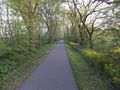
On the road
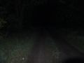
Last bit before the hash, walking an unlit road.
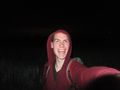
At the hash!
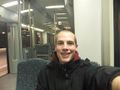
On the way back.


Achievements
Kattapa earned the Land geohash achievement
|