Difference between revisions of "2012-05-03 62 17"
imported>Jiml m (Result codes look correct) |
imported>FippeBot m (Location) |
||
| Line 76: | Line 76: | ||
[[Category:Expedition without GPS]] | [[Category:Expedition without GPS]] | ||
[[Category:Coordinates reached]] | [[Category:Coordinates reached]] | ||
| + | {{location|SE|Y}} | ||
Latest revision as of 03:46, 13 August 2019
| Thu 3 May 2012 in 62,17: 62.4324494, 17.3331714 geohashing.info google osm bing/os kml crox |
Location
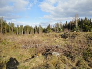
Hash was surveyed to be in the forest between the shopping area of Birsta and the city of Sundsvall.
Participants
Plans
My plans were to go to Birsta, do a little shopping and then go to the hashpoint, followed by a visit to my sister.
Expedition
I set out with the bus to reach Birsta, where I was getting off to do a little shopping before walking over to the hashpoint. After that I climbed up into the forest behind Bauhaus, getting up on top of the mountain behind it where I for some reason happened upon a park bench. I saw nothing resembling an actual path leading there so I don't really know why it even was there. Then I went downhill a little until I reached the logging grounds (again) where the hashpoint was.
After doing a bit of triangulation I located the hashpoint. I then walked over to it and enjoyed the sun. I of course forgot to take a picture of myself, but at least I took a picture of the surroundings. After that I went home to my sister for a bit before going back home.
Tracklog
No GPS, no log.
Photos
Achievements
Penthok earned the Land geohash achievement
|
Penthok earned the Public transport geohash achievement
|
Penthok earned the No Batteries Geohash Achievement
|


