Difference between revisions of "2012-05-26 47 8"
From Geohashing
imported>Hijackal m (→Achievements: template fail) |
imported>Hijackal (→Achievements: + mouseover achievement) |
||
| Line 48: | Line 48: | ||
{{land geohash | latitude = 47 | longitude = 8 | date = 2012-05-26| name = [[User:Frizzy|Frizzy]] and [[User:Hijackal|Hijackal]]}} | {{land geohash | latitude = 47 | longitude = 8 | date = 2012-05-26| name = [[User:Frizzy|Frizzy]] and [[User:Hijackal|Hijackal]]}} | ||
{{Walk geohash | latitude = 47 | longitude = 8 | date = 2012-05-26 | name = [[User:Hijackal|Hijackal]] and [[User:Frizzy]] | distance = 20 km (15+5) }} | {{Walk geohash | latitude = 47 | longitude = 8 | date = 2012-05-26 | name = [[User:Hijackal|Hijackal]] and [[User:Frizzy]] | distance = 20 km (15+5) }} | ||
| + | |||
| + | {{Geohashing Day | latitude = 47 | longitude = 8 | year = 2012 | coorddate= 2012-05-26 | mouseover = true | name = [[User:Frizzy|Frizzy]] and [[User:Hijackal|Hijackal]] | celebration = hiking away from cool Lake Constance through dust and sun | image = 2012-05-26_47_8_flipflop.JPG }} | ||
Revision as of 07:03, 30 May 2012
| Sat 26 May 2012 in 47,8: 47.8302435, 8.9436386 geohashing.info google osm bing/os kml crox |
Location
A field between Stockach and Radolfzell, just off the NW tip of Lake Constance.
Participants
Plans
The hash is about 10 km from where Frizzy and Hijackal will spend the weekend, so a walk hash should be possible. Maybe in time for a regular Mouseover meetup...
Expedition
Tracklog
Photos
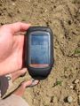
GPS-proof.
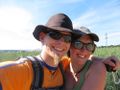
Happy hashers.
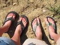
Hiking shoes.


Achievements
Frizzy and Hijackal earned the Land geohash achievement
|
Hijackal and User:Frizzy earned the Walk geohash Achievement
|
Frizzy and Hijackal earned the 2012 Mouse Over Day achievement
|