Difference between revisions of "2012-06-10 -37 145"
imported>Felix Dance m (→Photos) |
imported>Felix Dance m |
||
| Line 1: | Line 1: | ||
| − | |||
| − | |||
| − | |||
| − | |||
| − | |||
| − | |||
| − | |||
| − | |||
| − | |||
{{meetup graticule | {{meetup graticule | ||
| lat=-37 | | lat=-37 | ||
| Line 13: | Line 4: | ||
| date=2012-06-10 | | date=2012-06-10 | ||
}} | }} | ||
| − | |||
__NOTOC__ | __NOTOC__ | ||
Revision as of 23:00, 11 June 2012
| Sun 10 Jun 2012 in -37,145: -37.0537277, 145.7302875 geohashing.info google osm bing/os kml crox |
Location
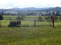
In a paddock near Merton, NE of Melbourne
Participants
- Felix Dance
- Stevage
- tAlex and
- Andrew
Expedition
We were all headed off on a rail-trail-cycle-tour of Stevage's devising, along with about a dozen others, staying in Bonnie Doon of 'The Castle' fame and heading to Molesworth up-line. tALex discovered this geohash the previous night before our train ride up so, it being roughly accessible, we went for it while the others all headed off towards their night's camping ground.
The weather was terrific, despite it being early winter, with clear skies and warm weather. We turned off the rail-trail after over-shooting by a few hundred metres and headed up a dirt road in the direction of the arrows on the various GPSs with us.
After some of the way we passed a row of dead foxes, no doubt installed to warn off the others from the attached farm. Soon, after a brief legal discussion on trespassing with our new geohashing member and lawyer, Andrew, we were opening paddock gates to make a strike for the hash.
In many of the varied paddocks we passed through, luckily without being accosted by any farmers, we had to herd cattle away from our intended paths - they'd eye us off warily wondering who was supposed to be charging whom - before deciding that they were the weaker party and fleeing to the far corner.
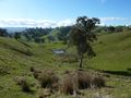
A few streams and rocky paths and muddy bogs and we were as far as the bikes could travel. Dumping them, we clambered through a barbed wire fence and ambled up the slope of the amazingly picturesque and steep valley to the hash-point. Taking some photos we soon returned as we had about 75kms left to ride that day, retracing our steps, opening and closing the same gates, Stevage fixing his hashflat and getting cowshit all over his hands, later to be eating a pie with his fingers without having washed them.
All-in-all, a total success. We even got to camp not too long after dark.
- Geohash success -- Talex @-37.0538,145.7303 22:56, 9 June 2012 (EDT)
Photos
tAlex's Photo

Felix' Photos
Dead foxes
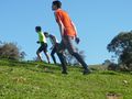
Giant tAlex
hashpaddock
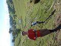
Geohash!
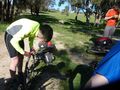
Stevage fixing a hashflat


Achievements
- Land Geohash
- Bike Geohash?
- Drag-along?