Difference between revisions of "2012-06-10 46 -121"
From Geohashing
imported>Kydlt (→Photos) |
imported>Kydlt |
||
| Line 31: | Line 31: | ||
[[Category:Expeditions]] | [[Category:Expeditions]] | ||
[[Category:Expeditions with photos]] | [[Category:Expeditions with photos]] | ||
| + | [[Category:Coordinates not reached]] | ||
| + | [[Category:Not reached - Mother Nature]] | ||
Revision as of 01:22, 11 June 2012
| Sun 10 Jun 2012 in 46,-121: 46.0537277, -121.7302875 geohashing.info google osm bing/os kml crox |
Location
Near Hidden Lake in the Gifford Pinchot National Forest.
Participants
Plans
Twas a sunny Sunday. Took a trip to the Guler Ice Cave, and go on deeper into the wilderness.
Expedition
A fail, as far as the hash goes. The cave was lovely but we only went in the mouth. Going up the unpaved Two Buttes Rd (NF-24) we ran in to uncleared and unmelted SNOW at about 3600 ft. So we turned back at 46.009747, -121.664701, about 4 1/2 miles short of the mark.
Tracklog
File:2012-06-10 45 -121 Turn back.gpx
Photos
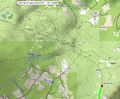
A map with where I wanted to go and where I went.
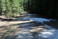
We neglected to take a photo where the road dissapeared under the snow. It was a couple 100 yards from here.

Not having a photo of me at the hash, here is a picture in the cave.
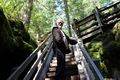
And climbing out of the sinkhole.


