Difference between revisions of "2010-02-25 47 -122"
From Geohashing
imported>Thomcat (Photos added) |
imported>FippeBot m (Location) |
||
| Line 31: | Line 31: | ||
[[Category:Expeditions with photos]] | [[Category:Expeditions with photos]] | ||
[[Category:Coordinates reached]] | [[Category:Coordinates reached]] | ||
| + | {{location|US|WA|KN}} | ||
Latest revision as of 00:59, 9 August 2019
| Thu 25 Feb 2010 in 47,-122: 47.7229938, -122.2452810 geohashing.info google osm bing/os kml crox |
Location
Near the road, on Juanita, near Bastyr University.
Participants
Expedition
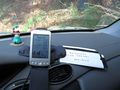
Printer was on the fritz, so I scribbled the coordinates on the inside of a chocolate bar wrapper. We here in the NorthWest are all about Reduce, Reuse and Recycle - after the coordinates were used, into the recycle bin it went!
First I visited Spud, because geohashing on a full stomach hasn't steered me wrong yet. I then parked on the side of the road to scout the actual hash location. The side of the road was banked up a bit, but there was a trail leading into it.
... and right to the Hash Point. Success!
Photos
The spot is near
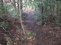
A nice trail
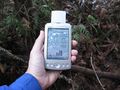
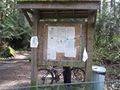
The spot is here
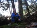
Another hasher? Nope.


