Difference between revisions of "2012-06-15 50 -1"
imported>QuarterCacher (Coordinates reached. :-)) |
imported>Mampfred m (report) |
||
| Line 21: | Line 21: | ||
== Expedition == | == Expedition == | ||
| − | + | After a veery nice meal from our hosts (very good Lasagne followed by home-made Apple Pie) we were off to a 40 minute drive. | |
| + | |||
| + | When we got in the general area of the hash we noticed that streets in the country are not only a lot narrower than in germany, it's also quite hard to spontaneously park somewhere in order to start hiking to the hash. So we circled the hash for a bit to find such a spot and eventually got lucky. | ||
| + | |||
| + | With some more luck, we actually parked right in front of a footpath that would pretty much lead us directly to the hash. We followed it along and at that point for the first time realized what our host had meant with the serious rain the UK had seen over the last weeks. Since we entered the country after that, we couldn't quiet believe how bad it had been until then. Fortunately most of us (hehe) had good shoes so made good progress. | ||
| + | |||
| + | We found the hash to be just off the footpath in some trees. Reception was terrible so we ended up waiting for [[User:QuarterCacher|QuarterCacher]] to finish his GPS dance. In the meantime Mampfred had the rest of the crew listen to [http://www.youtube.com/watch?v=nQrdxtWgHbE this] :) | ||
| + | |||
| + | On our way back from the hash we went to a pub in Buley for somefood and drinks and decided to go for a geocache to finish off the day. The candidate was which we easily found during another nice little walk through the country. | ||
| + | |||
| + | UK hash - done :D | ||
| + | |||
| + | (possibly more to come though) | ||
== Tracklog == | == Tracklog == | ||
| − | + | See [http://www.everytrail.com/view_trip.php?trip_id=1627952 here] (whole trip including Buley, the missing bit indicating our batteries running out at some point). | |
== Photos == | == Photos == | ||
| − | |||
| − | |||
| − | |||
<gallery perrow="5"> | <gallery perrow="5"> | ||
| − | |||
Image:2012-06-15_50_-1_17-47-45-790.jpg | Coordinates reached. :-) | Image:2012-06-15_50_-1_17-47-45-790.jpg | Coordinates reached. :-) | ||
</gallery> | </gallery> | ||
| Line 37: | Line 45: | ||
== Achievements == | == Achievements == | ||
{{#vardefine:ribbonwidth|800px}} | {{#vardefine:ribbonwidth|800px}} | ||
| − | + | * Land | |
| − | |||
| − | |||
| − | |||
| − | |||
[[Category:Expeditions]] | [[Category:Expeditions]] | ||
| − | |||
[[Category:Expeditions with photos]] | [[Category:Expeditions with photos]] | ||
| − | |||
| − | |||
| − | |||
| − | |||
| − | |||
[[Category:Coordinates reached]] | [[Category:Coordinates reached]] | ||
| − | |||
| − | |||
| − | |||
| − | |||
| − | |||
| − | |||
| − | |||
| − | |||
| − | |||
| − | |||
Revision as of 07:07, 16 June 2012
| Fri 15 Jun 2012 in 50,-1: 50.9495207, -1.8169494 geohashing.info google osm bing/os kml crox |
Location
Within some trees somewhere in the UK ...
Participants
Plans
Haaaaaash in the U-u-K! (think Born in the U-S-A).
Expedition
After a veery nice meal from our hosts (very good Lasagne followed by home-made Apple Pie) we were off to a 40 minute drive.
When we got in the general area of the hash we noticed that streets in the country are not only a lot narrower than in germany, it's also quite hard to spontaneously park somewhere in order to start hiking to the hash. So we circled the hash for a bit to find such a spot and eventually got lucky.
With some more luck, we actually parked right in front of a footpath that would pretty much lead us directly to the hash. We followed it along and at that point for the first time realized what our host had meant with the serious rain the UK had seen over the last weeks. Since we entered the country after that, we couldn't quiet believe how bad it had been until then. Fortunately most of us (hehe) had good shoes so made good progress.
We found the hash to be just off the footpath in some trees. Reception was terrible so we ended up waiting for QuarterCacher to finish his GPS dance. In the meantime Mampfred had the rest of the crew listen to this :)
On our way back from the hash we went to a pub in Buley for somefood and drinks and decided to go for a geocache to finish off the day. The candidate was which we easily found during another nice little walk through the country.
UK hash - done :D
(possibly more to come though)
Tracklog
See here (whole trip including Buley, the missing bit indicating our batteries running out at some point).
Photos
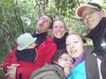
Coordinates reached. :-)

Achievements
- Land