Difference between revisions of "2012-06-17 32 -117"
imported>JesseW (add no trespass ribbon) |
imported>LucasBrown (→Achievements) |
||
| Line 51: | Line 51: | ||
{{#vardefine:ribbonwidth|800px}} | {{#vardefine:ribbonwidth|800px}} | ||
{{No trespassing |latitude=32 |longitude=-117 |date=2012-06-17 |image=2012-06-17 32 -117 3 Warning sign.jpg |name= [[User:JesseW|JesseW]]}} | {{No trespassing |latitude=32 |longitude=-117 |date=2012-06-17 |image=2012-06-17 32 -117 3 Warning sign.jpg |name= [[User:JesseW|JesseW]]}} | ||
| − | + | {{Meet-up | latitude = 32 | longitude = -117 | date = 2012-06-17 | name = LucasBrown}} | |
| − | |||
| − | |||
| − | |||
| − | |||
| − | |||
| − | |||
| − | |||
[[Category:Expeditions]] | [[Category:Expeditions]] | ||
[[Category:Expeditions with photos]] | [[Category:Expeditions with photos]] | ||
[[Category:Coordinates reached]] | [[Category:Coordinates reached]] | ||
| − | |||
| − | |||
| − | |||
| − | |||
| − | |||
| − | |||
| − | |||
| − | |||
| − | |||
| − | |||
| − | |||
| − | |||
| − | |||
| − | |||
| − | |||
| − | |||
| − | |||
| − | |||
Revision as of 15:45, 19 July 2012
| Sun 17 Jun 2012 in 32,-117: 32.8176662, -117.0583536 geohashing.info google osm bing/os kml crox |
Location
Just off of Mission Gorge Rd, near Jackson Dr.
Participants
- JesseW
- LucasBrown -- reached the hashpoint at about 12:15.
Plans
Going to head out as soon as possible, probably getting there by 10:30 AM. JesseW 12:29, 17 June 2012 (EDT)
Expedition
It was very easy. Drove out to the Jackson Dr. intersection, parked in the overflow parking lot, walked a few minutes down the path, to the closest point (about 17 meters away, give or take 3 meters). Asked some fellow hikers to take a picture of me, and took pictures of my GPS. I didn't go off the path because it was fragile county (see sign pictured below). Then I walked around to the closest point on the road, which was also about the same distance away from the hash (on the other side), and snapped a few more shots. Pictures & tracklog to come. JesseW 16:19, 17 June 2012 (EDT)
My expedition followed essentially the same route, but stepped carefully off the path to the hashpoint itself. Met a fellow hasher who was out on his first expedition. LucasBrown
- That's great! I'm sorry I missed you two. Hopefully the person you met will make a wiki account and post their own write-up. JesseW 02:54, 18 June 2012 (EDT)
Tracklog
Photos
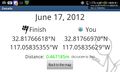
Less than a meter from the hashpoint (LucasBrown) @32.8177,-117.0583
The hashpoint (LucasBrown) @32.8177,-117.0584
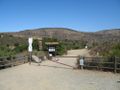
The area where JesseW parked.
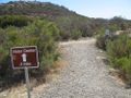
The trail that led closest to the hash.
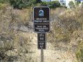
Why JesseW didn't actually reach the coordinates.
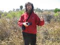
JesseW, as close as I got.
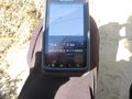
What JesseW's GPS said at that point.
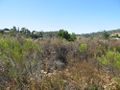
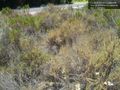
What the hash looked like, from the trail.
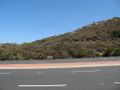
And what it looked like from the other direction, looking across Mission Gorge Rd.
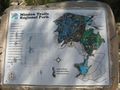
A map of the park in which the hashpoint was located.


Achievements
JesseW earned the No trespassing consolation prize
|
LucasBrown earned the Meet-up achievement
|