Difference between revisions of "2012-06-22 48 11"
imported>Zertrin (init) |
imported>Zertrin (expedition report) |
||
| Line 1: | Line 1: | ||
| − | |||
| − | |||
| − | |||
| − | |||
| − | |||
| − | |||
| − | |||
| − | |||
| − | |||
| − | |||
{{meetup graticule | {{meetup graticule | ||
| lat=48 | | lat=48 | ||
| Line 14: | Line 4: | ||
| date=2012-06-22 | | date=2012-06-22 | ||
}} | }} | ||
| + | |||
| + | [[Image:2012-06-22 Geohash+Track Google Maps.png|600px]] | ||
<!-- edit as necessary --> | <!-- edit as necessary --> | ||
| Line 19: | Line 11: | ||
== Location == | == Location == | ||
<!-- where you've surveyed the hash to be --> | <!-- where you've surveyed the hash to be --> | ||
| + | The hash was located in the forest, about 30 meter from the road between Neuried and Gauting, 10 km SW of Munich. | ||
== Participants == | == Participants == | ||
| − | + | [[User:Zertrin|Zertrin]] | |
| − | |||
== Plans == | == Plans == | ||
| − | + | * [[2012-06-22 48 11]] An easy one tomorrow. I might go by bike in the end of the afternoon after university stuff. No ETA yet, but it should be between 16:00 and 18:30. — [[User:Zertrin|Zertrin]] 11:57, 21 June 2012 (EDT) | |
== Expedition == | == Expedition == | ||
<!-- how it all turned out. your narrative goes here. --> | <!-- how it all turned out. your narrative goes here. --> | ||
| + | After my last lecture this Friday, I took my bike and my brand new eTrex 20 that I got for birthday to ride to the hash. The trip was uneventful. Approaching the point, I went off the road to find a way to approach the hash. I parked my bike a few meter after entering the forest and the made the last 30 meters by foot. This was not very easy (again a lot of cut wood on the ground that makes the way difficult to cross... | ||
| + | |||
| + | I finally reached the haspoint, took some pictures and then went back to my home. | ||
== Tracklog == | == Tracklog == | ||
| Line 37: | Line 32: | ||
Image:2010-##-## ## ## Alpha.jpg | Witty Comment | Image:2010-##-## ## ## Alpha.jpg | Witty Comment | ||
--> | --> | ||
| − | <gallery perrow=" | + | <gallery perrow="4"> |
| + | Image:2012-06-22 Zertrin GPS Waypoint.JPG | Today's coords | ||
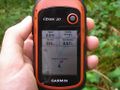
| + | Image:2012-06-22 Zertrin GPS Map.JPG | | ||
| + | Image:2012-06-22 Zertrin GPS Compass.JPG | Within the accuracy range | ||
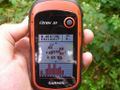
| + | Image:2012-06-22 Zertrin GPS Satellites.JPG | | ||
| + | Image:2012-06-22 Zertrin at hashpoint.JPG | | ||
| + | Image:2012-06-22 the hashpoint.JPG | The hashpoint | ||
| + | Image:2012-06-22 Zertrin's bike in the woods.JPG | My bike parked in the woods | ||
| + | Image:2012-06-22 Zertrin's bike by the road.JPG | Along the road, the way to the hash is at the right of this picture. | ||
</gallery> | </gallery> | ||
| Line 43: | Line 46: | ||
{{#vardefine:ribbonwidth|800px}} | {{#vardefine:ribbonwidth|800px}} | ||
<!-- Add any achievement ribbons you earned below, or remove this section --> | <!-- Add any achievement ribbons you earned below, or remove this section --> | ||
| + | {{Bicycle geohash | latitude = 48 | longitude = 11 | date = 2012-06-22 | name = Zertrin | distance = 20 km | image = Zertrin_at_hash_2012-06-22_48_11.JPG }} | ||
| − | |||
| − | |||
| − | |||
| − | |||
| − | |||
| − | |||
| − | |||
| − | |||
| − | |||
| − | |||
| − | |||
[[Category:Expeditions]] | [[Category:Expeditions]] | ||
| − | |||
[[Category:Expeditions with photos]] | [[Category:Expeditions with photos]] | ||
| − | + | ||
| − | |||
| − | |||
| − | |||
| − | |||
[[Category:Coordinates reached]] | [[Category:Coordinates reached]] | ||
| − | |||
| − | |||
| − | |||
| − | |||
| − | |||
| − | |||
| − | |||
| − | |||
| − | |||
| − | |||
Revision as of 17:26, 22 June 2012
| Fri 22 Jun 2012 in 48,11: 48.0739489, 11.4241655 geohashing.info google osm bing/os kml crox |

Location
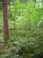
The hash was located in the forest, about 30 meter from the road between Neuried and Gauting, 10 km SW of Munich.
Participants
Plans
- 2012-06-22 48 11 An easy one tomorrow. I might go by bike in the end of the afternoon after university stuff. No ETA yet, but it should be between 16:00 and 18:30. — Zertrin 11:57, 21 June 2012 (EDT)
Expedition
After my last lecture this Friday, I took my bike and my brand new eTrex 20 that I got for birthday to ride to the hash. The trip was uneventful. Approaching the point, I went off the road to find a way to approach the hash. I parked my bike a few meter after entering the forest and the made the last 30 meters by foot. This was not very easy (again a lot of cut wood on the ground that makes the way difficult to cross...
I finally reached the haspoint, took some pictures and then went back to my home.
Tracklog
Photos
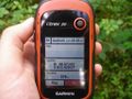
Today's coords
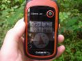
Within the accuracy range
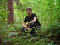
The hashpoint
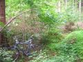
My bike parked in the woods
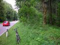
Along the road, the way to the hash is at the right of this picture.


Achievements
Zertrin earned the Bicycle geohash achievement
|