Difference between revisions of "2012-06-29 50 -120"
From Geohashing
imported>Wijnland |
imported>Wijnland (file report) |
||
| Line 1: | Line 1: | ||
| − | + | [[Image:20120629_50-120-8513.jpg |thumb|left]] | |
| − | |||
| − | |||
| − | |||
| − | |||
| − | |||
| − | |||
{{meetup graticule | {{meetup graticule | ||
| lat=50 | | lat=50 | ||
| Line 23: | Line 17: | ||
* [[User:Wijnland|Wijnland]] | * [[User:Wijnland|Wijnland]] | ||
* [[User:Rogier|Rogier]] | * [[User:Rogier|Rogier]] | ||
| − | + | * Maarten | |
| − | |||
== Plans == | == Plans == | ||
go by there on a long weekend trip to (lytton, Merrit, kamloops, pemberton, vancouvert) | go by there on a long weekend trip to (lytton, Merrit, kamloops, pemberton, vancouvert) | ||
| − | |||
== Expedition == | == Expedition == | ||
| − | + | The point was in a hayfield with pivot irrigation just north of Merrit along highway 5. We took highway 5A from Merrit because it was a lot easier and safer to stop there and walk up to the hash. Luckily the field was already cut and the hay was in bales so there was no problem in quickly walking into the field to find our location. There were some big hay bales precisely at the hash, but we could come within the accuracy of the gps without climbing on any of them. | |
| − | |||
| − | |||
| − | |||
== Photos == | == Photos == | ||
| Line 41: | Line 30: | ||
--> | --> | ||
<gallery perrow="5"> | <gallery perrow="5"> | ||
| + | Image:20120629_50-120-8508.jpg | Coordinates reached | ||
| + | Image:20120629 50-120-8504.jpg | ||
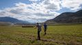
| + | Image:20120629 50-120-8511.jpg | [[User:Rogier|Rogier]] and Maarten at location | ||
| + | Image:20120629_50-120-8514.jpg | ||
| + | Image:20120629_50-120-4975.jpg | Infrared pic of hash | ||
</gallery> | </gallery> | ||
== Achievements == | == Achievements == | ||
| − | |||
| − | |||
| − | |||
| − | |||
| − | |||
| − | |||
| − | |||
| − | |||
| − | |||
[[Category:Expeditions with photos]] | [[Category:Expeditions with photos]] | ||
| − | |||
| − | |||
| − | |||
| − | |||
| − | |||
[[Category:Coordinates reached]] | [[Category:Coordinates reached]] | ||
| − | |||
| − | |||
| − | |||
| − | |||
| − | |||
| − | |||
| − | |||
| − | |||
| − | |||
| − | |||
Revision as of 03:59, 3 July 2012

| Fri 29 Jun 2012 in 50,-120: 50.1425171, -120.7250589 geohashing.info google osm bing/os kml crox |
Location
just of the coquihalla north of Merrit
Participants
Plans
go by there on a long weekend trip to (lytton, Merrit, kamloops, pemberton, vancouvert)
Expedition
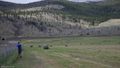
The point was in a hayfield with pivot irrigation just north of Merrit along highway 5. We took highway 5A from Merrit because it was a lot easier and safer to stop there and walk up to the hash. Luckily the field was already cut and the hay was in bales so there was no problem in quickly walking into the field to find our location. There were some big hay bales precisely at the hash, but we could come within the accuracy of the gps without climbing on any of them.
Photos
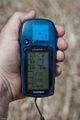
Coordinates reached

Rogier and Maarten at location
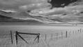
Infrared pic of hash


