Difference between revisions of "2012-06-30 33 -116"
From Geohashing
imported>NWoodruff |
imported>Eldin m (clean up template, check categories, and add achievement banners.) |
||
| Line 5: | Line 5: | ||
}} | }} | ||
| − | |||
__NOTOC__ | __NOTOC__ | ||
== Location == | == Location == | ||
| Line 14: | Line 13: | ||
== Photos == | == Photos == | ||
| − | |||
| − | |||
| − | |||
<gallery perrow="5"> | <gallery perrow="5"> | ||
| Line 28: | Line 24: | ||
== Achievements == | == Achievements == | ||
{{#vardefine:ribbonwidth|800px}} | {{#vardefine:ribbonwidth|800px}} | ||
| − | + | {{land geohash | |
| − | + | | latitude = 33 | |
| − | + | | longitude = -116 | |
| − | + | | date = 2012-06-30 | |
| − | + | | name = [[User:LucasBrown|LucasBrown]] | |
| − | + | }} | |
| − | |||
| − | |||
| − | |||
| − | [[ | ||
| − | |||
[[Category:Expeditions]] | [[Category:Expeditions]] | ||
[[Category:Expeditions with photos]] | [[Category:Expeditions with photos]] | ||
| − | |||
[[Category:Coordinates reached]] | [[Category:Coordinates reached]] | ||
| − | |||
| − | |||
| − | |||
| − | |||
| − | |||
| − | |||
| − | |||
| − | |||
| − | |||
Revision as of 04:52, 17 May 2013
| Sat 30 Jun 2012 in 33,-116: 33.2420946, -116.6615016 geohashing.info google osm bing/os kml crox |
Location
Under a tree in a pasture used for horses off San Felipe Road, just south of Warner Springs
Participants
Photos
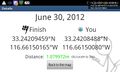
Geohash Droid details page at the hashpoint
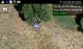
Geohash Droid map at the hashpoint
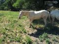
A horse standing on the hashpoint


Achievements
LucasBrown earned the Land geohash achievement
|