Difference between revisions of "2012-07-01 52 5"
imported>Elwingelfje |
imported>Elwingelfje |
||
| Line 21: | Line 21: | ||
== Photos == | == Photos == | ||
| − | |||
| − | |||
<gallery perrow="5"> | <gallery perrow="5"> | ||
| Line 28: | Line 26: | ||
Image:2012-07-01 52 5 street name fail.jpg | Pointing the camera the right way is too hard. | Image:2012-07-01 52 5 street name fail.jpg | Pointing the camera the right way is too hard. | ||
Image:2012-07-01 52 5 really stupid grin and street name.jpg | The hashpoint is more or less at my neck. | Image:2012-07-01 52 5 really stupid grin and street name.jpg | The hashpoint is more or less at my neck. | ||
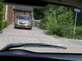
| + | Image:2012-07-01 52 5 me in car.jpg | Another one of the driveway taken from my car (because I didn't want to scare the property owner). | ||
</gallery> | </gallery> | ||
Revision as of 17:03, 1 July 2012
| Sun 1 Jul 2012 in 52,5: 52.8506096, 5.7131653 geohashing.info google osm bing/os kml crox |
Location
Lemmer, Friesland
Participants
Plans
Go there by car; take some pictures and leave.
Expedition
This was a very easy hash. The hashpoint is located just in front of someone's driveway, but not actually on private terrain. Also it's extremely easy go get there by car: take the Lemmer exit from the A6 highway; first way right; first way right; first way left and then you're as good as there. This also meant that I could find the hash without the help of any electronic equipment whatsoever, earning me the No Batteries achievement. The only obstacle was the owner of the property: he was working on something in his backyard in a spot where he could see the driveway, and he seemed a bit alarmed by me hanging out suspiciously in front of his house and sneakily taking pictures. This explains the somewhat lacking quality of the pictures.
I found it a bit of a bore to drive 50 km back and forth to Lemmer just to stand by someone's driveway, so I decided to visit the Ir D.F. Woudagemaal. This is the largest still operating steam-powered pumping station in the entire world. It is also a UNESCO World Heritage site. When the electric-powered pumping stations in this part of the Netherlands can't cope with the water load (because there is too much water, or because the water level in the sea is too high to let the water drain easily) the Woudagemaal kicks into action and keeps everybody's feet dry. The last time this happened was last January. It was built in 1920, and before this time there was flooding of certain areas and houses in Friesland almost every winter, which is hard to imagine now. They had an excellent visitors centre and a tour by an enthusiastic guide. An Australian elderly couple was visiting at the same time as me, and I translated for them so that they could follow the tour as well.
Photos

In the car just before leaving home

Pointing the camera the right way is too hard.

The hashpoint is more or less at my neck.
Another one of the driveway taken from my car (because I didn't want to scare the property owner).


Achievements
elwingelfje earned the Land geohash achievement
|
elwingelfje earned the No Batteries Geohash Achievement
|
elwingelfje achieved level 1 of the Minesweeper Geohash achievement
|