Difference between revisions of "2012-07-30 50 8"
imported>Mampfred m (Created page with "{{subst:Expedition |lat = 50 |lon = 8 |date = 2012-07-30 }}") |
imported>Mampfred |
||
| Line 1: | Line 1: | ||
| − | |||
| − | |||
| − | |||
| − | |||
| − | |||
| − | |||
| − | |||
| − | |||
| − | |||
| − | |||
{{meetup graticule | {{meetup graticule | ||
| lat=50 | | lat=50 | ||
| Line 15: | Line 5: | ||
}} | }} | ||
| − | |||
__NOTOC__ | __NOTOC__ | ||
== Location == | == Location == | ||
| − | + | Not far from the [http://www.berggasthof-herzberg.de Berggasthof Herzberg] on the Herzberg, which is a 450 meter high hill in the Taununs with lotsof history (*yawn*). | |
== Participants == | == Participants == | ||
| − | + | * [[User:QuarterCacher|QuarterCacher]] | |
| − | + | * [[User:Mampfred|Mampfred]] | |
| + | |||
| + | == Expedition == | ||
| + | QuarterCacher very nearly made it a midnight hash but in the end he coulsn't be bothered and we started our expedition after work on monday. | ||
| + | |||
| + | We knew that the hash wouldn't be far from the [http://www.berggasthof-herzberg.de Berggasthof Herzberg]. But you can't always get there by car as the area is closed for cars on the weekends and the restaurant is closed on mondays, so we weren't sure how far we'd get. | ||
| + | |||
| + | Those doubts turned out to be unnecessary though as we could drive all the way to the top. We would have loved to have a closer look at the tower at this point but unfortunately it's not open when the restaurant is closed, so we had to have a look from the outside only. | ||
| − | + | From there, we started decending through small paths in the woods towards the hash. We'd seen a mixture of open spaces and thick bushes everywhere so it didn't look good when we approached the last hundred meters and all we could see were those bushes. Luckily we found a little detour around them and could just about catch the hash from the other side with just a little crawling around ;) | |
| − | |||
| − | + | We headed back up the top and drove back to civilization. Uneventful and easy, but a nice walk and some exercise going back up the hill. | |
| − | |||
== Tracklog == | == Tracklog == | ||
| − | + | See [http://www.everytrail.com/view_trip.php?trip_id=1697130 here]. | |
== Photos == | == Photos == | ||
| − | |||
| − | |||
| − | |||
<gallery perrow="5"> | <gallery perrow="5"> | ||
| + | Image:2012-07-30_50_8_herzberg_tower.jpg | The Herzberg Tower. | ||
| + | Image:2012-07-30_50_8_herzberg_tower_plate.jpg | And the plaque at its base. | ||
| + | Image:2012-07-30_50_8_herzberg_tower_opening.jpg | Unfortunately not open on MONDAYS :( | ||
| + | Image:2012-07-30_50_8_herzberg_tower_turnstile.jpg | And they obviously want you o stay out ... | ||
| + | Image:2012-07-30_50_8_track.jpg | One of the bigger tracks. | ||
| + | Image:2012-07-30_50_8_coordinates_reached.jpg | Coordinates reached (0m screenshot coming later => other GPS) | ||
| + | Image:2012-07-30_50_8_hash.jpg | The hash. | ||
| + | Image:2012-07-30_50_8_stupid_grin.jpg | A slightly dark but nonetheless stupid grin. | ||
</gallery> | </gallery> | ||
== Achievements == | == Achievements == | ||
{{#vardefine:ribbonwidth|800px}} | {{#vardefine:ribbonwidth|800px}} | ||
| − | + | * Land | |
| − | |||
| − | |||
| − | |||
| − | |||
| − | |||
| − | |||
| − | |||
| − | |||
| − | |||
| − | |||
| − | |||
[[Category:Expeditions]] | [[Category:Expeditions]] | ||
| − | |||
[[Category:Expeditions with photos]] | [[Category:Expeditions with photos]] | ||
| − | |||
| − | |||
| − | |||
| − | |||
| − | |||
[[Category:Coordinates reached]] | [[Category:Coordinates reached]] | ||
| − | |||
| − | |||
| − | |||
| − | |||
| − | |||
| − | |||
| − | |||
| − | |||
| − | |||
| − | |||
| − | |||
| − | |||
| − | |||
| − | |||
| − | |||
| − | |||
| − | |||
| − | |||
Revision as of 08:30, 31 July 2012
| Mon 30 Jul 2012 in 50,8: 50.2517686, 8.5457375 geohashing.info google osm bing/os kml crox |
Location
Not far from the Berggasthof Herzberg on the Herzberg, which is a 450 meter high hill in the Taununs with lotsof history (*yawn*).
Participants
Expedition
QuarterCacher very nearly made it a midnight hash but in the end he coulsn't be bothered and we started our expedition after work on monday.
We knew that the hash wouldn't be far from the Berggasthof Herzberg. But you can't always get there by car as the area is closed for cars on the weekends and the restaurant is closed on mondays, so we weren't sure how far we'd get.
Those doubts turned out to be unnecessary though as we could drive all the way to the top. We would have loved to have a closer look at the tower at this point but unfortunately it's not open when the restaurant is closed, so we had to have a look from the outside only.
From there, we started decending through small paths in the woods towards the hash. We'd seen a mixture of open spaces and thick bushes everywhere so it didn't look good when we approached the last hundred meters and all we could see were those bushes. Luckily we found a little detour around them and could just about catch the hash from the other side with just a little crawling around ;)
We headed back up the top and drove back to civilization. Uneventful and easy, but a nice walk and some exercise going back up the hill.
Tracklog
See here.
Photos
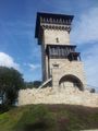
The Herzberg Tower.
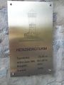
And the plaque at its base.
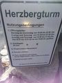
Unfortunately not open on MONDAYS :(
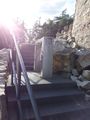
And they obviously want you o stay out ...
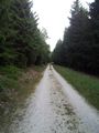
One of the bigger tracks.
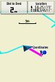
Coordinates reached (0m screenshot coming later => other GPS)
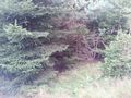
The hash.
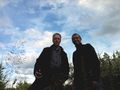
A slightly dark but nonetheless stupid grin.


Achievements
- Land