Difference between revisions of "2012-08-08 -31 115"
From Geohashing
imported>Nick mz |
imported>FippeBot m (Location) |
||
| Line 29: | Line 29: | ||
[[Category:Expeditions with photos]] | [[Category:Expeditions with photos]] | ||
[[Category:Coordinates reached]] | [[Category:Coordinates reached]] | ||
| + | {{location|AU|WA}} | ||
Revision as of 05:27, 13 August 2019
| Wed 8 Aug 2012 in -31,115: -31.9713206, 115.9072514 geohashing.info google osm bing/os kml crox |
Location
On a car park next to the Perth Football Club's Eftel Oval.
Expedition: nick_mz
As I mainly go to hashes that are conveniently accessible using public transport, the easy ones seem to be few and far between. This was another one. Walking a few hundred meters from Victoria Park Station on the Thornlie Line, I arrived at the Demon's football ground. To proceed, I had to explain what I was up to to two blokes in a ute. I obviously convinced them that I posed no threat to the property.
Gallery
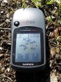
The obligatory picture of my GPS device.
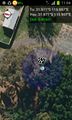
Screenshot of the app. The telephone disagreed with the Garmin device. Again.
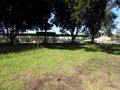
Looking into the Oval. Note the goal posts.
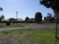
The opposite direction. Residential buildings.
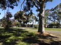
A tree next to the hash point, also the entry to the car park.


