Difference between revisions of "2012-08-04 51 -0"
imported>Huinesoron (More coming.) |
imported>Huinesoron (Mostly complete report) |
||
| Line 17: | Line 17: | ||
== Location == | == Location == | ||
This hash falls just inside the M25 London Ring Road, in a little town called Rickmansworth. I'd never in fact heard of Rickmansworth before, but since when has that been a problem? | This hash falls just inside the M25 London Ring Road, in a little town called Rickmansworth. I'd never in fact heard of Rickmansworth before, but since when has that been a problem? | ||
| + | |||
| + | According to Google Maps (an invaluable tool) the hash itself lay in some lucky soul's front garden - about ten metres from their front gate, at the junction of Nightingale Road and Meadow Way. Given the usual accuracy of GMaps, I'd be perfectly happy to reach the front gate. | ||
== Participants == | == Participants == | ||
| Line 24: | Line 26: | ||
The reason for my choosing this particular geohash was simple: I had a planned journey from my home graticule of [[London East, United Kingdom|51 0]] to [[Mid Wales, United Kingdom|52 -3]] (round the M25, up the M40, then the A 458 across Wales... far too long a drive, in my opinion. Wales should be closer), which would carry me and my family through a total of six graticules. "Surely," I thought, "there must be ''one'' hash within range of that trip!" | The reason for my choosing this particular geohash was simple: I had a planned journey from my home graticule of [[London East, United Kingdom|51 0]] to [[Mid Wales, United Kingdom|52 -3]] (round the M25, up the M40, then the A 458 across Wales... far too long a drive, in my opinion. Wales should be closer), which would carry me and my family through a total of six graticules. "Surely," I thought, "there must be ''one'' hash within range of that trip!" | ||
| − | There was. | + | There was. And it should only be a ten-minute diversion from The Trek. |
== Expedition == | == Expedition == | ||
| − | + | We set off at some unearthly hour in the morning - this was not going to be a 4pm meetup hash - heading for the clear blue/grey cloudy skies of Wales. Google Maps told me that it would only take ten extra minutes to hit the hash, so after cajoling my wife for some time, we turned off at Junction 18 and headed into Rickmansworth. | |
| + | |||
| + | Some commentary followed concerning the delightful buildings of said town, and how it's clearly quite a well-to-do area, and then - the turning! | ||
| + | |||
| + | I didn't turn. I didn't turn, ''because'' when GMaps shows that you have to go down and round the roundabout to reach Nightingale Road, it apparently knows what it's talking about. I intensely dislike No Right Turn signs. | ||
| − | + | Having obeyed the whims of Rickmansworth town planning, we sailed on down Nightingale Road, eyes wide for a sight of Meadow Way. | |
| − | + | ||
| + | "Oh, I think that was it..." | ||
| + | |||
| + | Three-point-turn in a road packed with parked cars. Is there space to park here? Not much of it, so let's head down Meadow Way. Well, there's plenty of space here... oh, that's because it's all No Parking. Curse you, Rickmansworth Town Planning! Time for another three-point-turn, and back to Nightingale. | ||
| + | |||
| + | I did eventually find a place to park, and abandoned my wife and two-year-old son to hike up to the hash. All right, 50 metres isn't much of a hike, but it counts, right? Victory was mine! | ||
| + | |||
| + | My victory was slightly tainted by the fact that, on the way back to the car, I realised I'd never bothered to clear the camera out. So, with a sigh, I hit Delete All... and turned around to get photos at the hashpoint again. ''Then'' I got back in the car and... went on driving. | ||
== Photos == | == Photos == | ||
| − | |||
| − | |||
| − | |||
<gallery perrow="5"> | <gallery perrow="5"> | ||
| + | Image:2012-08-04 51 -0 Mapview.jpg | The height of technology | ||
| + | Image:2012-08-04 51 -0 Maproute.jpg | Well, this looks easy | ||
| + | Image:2012-08-04 51 -0 Nightingale.jpg | Not much room for parking | ||
| + | Image:2012-08-04 51 -0 Meadow.jpg | No parking allowed! | ||
| + | Image:2012-08-04 51 -0 Hashpoint.jpg | The hashpoint is somewhere in front of that flowerpot | ||
| + | Image:2012-08-04 51 -0 Stupidvan.jpg | My first timer'd photo | ||
| + | Image:2012-08-04 51 -0 Stupidgrin.jpg | Timer success and Stupid Grin | ||
| + | Image:2012-08-04 51 -0 Disapproval.jpg | My wife does not Do geohashing | ||
</gallery> | </gallery> | ||
== Achievements == | == Achievements == | ||
{{#vardefine:ribbonwidth|800px}} | {{#vardefine:ribbonwidth|800px}} | ||
| − | + | {{land geohash | |
| + | | latitude = 51 | ||
| + | | longitude = -0 | ||
| + | | date = 2012-08-04 | ||
| + | | name = Huinesoron | ||
| + | | image = 2012-08-04 51 -0 Stupidgrin.jpg | ||
| + | }} | ||
| − | |||
| − | |||
| − | |||
| − | |||
| − | |||
| − | |||
| − | |||
| − | |||
| − | |||
| − | |||
[[Category:Expeditions]] | [[Category:Expeditions]] | ||
| − | |||
[[Category:Expeditions with photos]] | [[Category:Expeditions with photos]] | ||
| − | + | [[Category:Expedition without GPS]] | |
| − | [[Category:Expedition without GPS]] | ||
| − | |||
| − | |||
| − | |||
[[Category:Coordinates reached]] | [[Category:Coordinates reached]] | ||
| − | + | [[Category:Meetup on 2012-08-04]] | |
| − | + | [[Category:Meetup in 51 -0]] | |
| − | |||
| − | [[Category: | ||
| − | -- | ||
| − | |||
| − | |||
| − | |||
| − | |||
| − | [[Category: | ||
| − | |||
| − | |||
| − | |||
| − | |||
| − | |||
| − | |||
| − | |||
| − | |||
Revision as of 08:28, 12 August 2012
| Sat 4 Aug 2012 in 51,-0: 51.6396922, -0.4799171 geohashing.info google osm bing/os kml crox |
Location
This hash falls just inside the M25 London Ring Road, in a little town called Rickmansworth. I'd never in fact heard of Rickmansworth before, but since when has that been a problem?
According to Google Maps (an invaluable tool) the hash itself lay in some lucky soul's front garden - about ten metres from their front gate, at the junction of Nightingale Road and Meadow Way. Given the usual accuracy of GMaps, I'd be perfectly happy to reach the front gate.
Participants
Plans
The reason for my choosing this particular geohash was simple: I had a planned journey from my home graticule of 51 0 to 52 -3 (round the M25, up the M40, then the A 458 across Wales... far too long a drive, in my opinion. Wales should be closer), which would carry me and my family through a total of six graticules. "Surely," I thought, "there must be one hash within range of that trip!"
There was. And it should only be a ten-minute diversion from The Trek.
Expedition
We set off at some unearthly hour in the morning - this was not going to be a 4pm meetup hash - heading for the clear blue/grey cloudy skies of Wales. Google Maps told me that it would only take ten extra minutes to hit the hash, so after cajoling my wife for some time, we turned off at Junction 18 and headed into Rickmansworth.
Some commentary followed concerning the delightful buildings of said town, and how it's clearly quite a well-to-do area, and then - the turning!
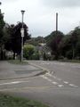
I didn't turn. I didn't turn, because when GMaps shows that you have to go down and round the roundabout to reach Nightingale Road, it apparently knows what it's talking about. I intensely dislike No Right Turn signs.
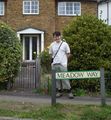
Having obeyed the whims of Rickmansworth town planning, we sailed on down Nightingale Road, eyes wide for a sight of Meadow Way.
"Oh, I think that was it..."
Three-point-turn in a road packed with parked cars. Is there space to park here? Not much of it, so let's head down Meadow Way. Well, there's plenty of space here... oh, that's because it's all No Parking. Curse you, Rickmansworth Town Planning! Time for another three-point-turn, and back to Nightingale.
I did eventually find a place to park, and abandoned my wife and two-year-old son to hike up to the hash. All right, 50 metres isn't much of a hike, but it counts, right? Victory was mine!
My victory was slightly tainted by the fact that, on the way back to the car, I realised I'd never bothered to clear the camera out. So, with a sigh, I hit Delete All... and turned around to get photos at the hashpoint again. Then I got back in the car and... went on driving.
Photos
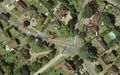
The height of technology
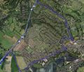
Well, this looks easy
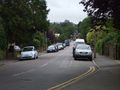
Not much room for parking
No parking allowed!
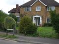
The hashpoint is somewhere in front of that flowerpot

My first timer'd photo
Timer success and Stupid Grin

My wife does not Do geohashing


Achievements
Huinesoron earned the Land geohash achievement
|