Difference between revisions of "2012-08-25 46 -123"
imported>AeroIllini (→Expedition) |
imported>Jiml m (Add result codes) |
||
| Line 14: | Line 14: | ||
}} | }} | ||
| − | + | ||
__NOTOC__ | __NOTOC__ | ||
== Location == | == Location == | ||
| − | + | ||
Just off Route 6, southwest of Centralia, WA. | Just off Route 6, southwest of Centralia, WA. | ||
== Participants == | == Participants == | ||
| − | + | ||
| − | + | * [[User:AeroIllini|AeroIllini]] | |
| − | [[User:AeroIllini|AeroIllini]] | ||
== Plans == | == Plans == | ||
| − | + | ||
The plan is to drive down to the point from Seattle in the morning, and then make a meetup in the [[Seattle]] graticule at 4 pm. | The plan is to drive down to the point from Seattle in the morning, and then make a meetup in the [[Seattle]] graticule at 4 pm. | ||
== Expedition == | == Expedition == | ||
| − | + | ||
The drive down to Centralia was uneventful. I turned onto Route 6 and immediately went into a cell service black hole. GPS coverage turned out to be spotty in the hills, as well. Luckily I had remembered the name of the road to turn on, which turned out to be a gravel road about half an hour down Route 6. Once on the gravel, I relied on the distance calculation provided by the Android app. Unfortunately, I was thwarted twice... once by No Trespassing sign, and once by some extremely marshy land when I tried to go around. I was not prepared to ford any rivers, so I stopped as close as I could to the point, which was about 600 ft distant. I'm calling this one a failure, unless someone else wants to declare that I have the benefit of the doubt and 600 ft is "close enough." | The drive down to Centralia was uneventful. I turned onto Route 6 and immediately went into a cell service black hole. GPS coverage turned out to be spotty in the hills, as well. Luckily I had remembered the name of the road to turn on, which turned out to be a gravel road about half an hour down Route 6. Once on the gravel, I relied on the distance calculation provided by the Android app. Unfortunately, I was thwarted twice... once by No Trespassing sign, and once by some extremely marshy land when I tried to go around. I was not prepared to ford any rivers, so I stopped as close as I could to the point, which was about 600 ft distant. I'm calling this one a failure, unless someone else wants to declare that I have the benefit of the doubt and 600 ft is "close enough." | ||
== Photos == | == Photos == | ||
| − | + | ||
| − | |||
| − | |||
<gallery perrow="5"> | <gallery perrow="5"> | ||
| − | |||
Image:2012-08-25_46_-123_14-23-15-704.jpg | The road leading to the point. [http://www.openstreetmap.org/?lat=46.56030000&lon=-123.36500000&zoom=16&layers=B000FTF @46.5603,-123.3650] | Image:2012-08-25_46_-123_14-23-15-704.jpg | The road leading to the point. [http://www.openstreetmap.org/?lat=46.56030000&lon=-123.36500000&zoom=16&layers=B000FTF @46.5603,-123.3650] | ||
| − | |||
Image:2012-08-25_46_-123_14-24-11-197.jpg | Me grinning, as close to the point as I could get. [http://www.openstreetmap.org/?lat=.00000000&lon=.00000000&zoom=16&layers=B000FTF @.0000,.0000] | Image:2012-08-25_46_-123_14-24-11-197.jpg | Me grinning, as close to the point as I could get. [http://www.openstreetmap.org/?lat=.00000000&lon=.00000000&zoom=16&layers=B000FTF @.0000,.0000] | ||
| − | |||
Image:2012-08-25_46_-123_14-25-35-079.jpg | Thwarted! [http://www.openstreetmap.org/?lat=46.56000000&lon=-123.36500000&zoom=16&layers=B000FTF @46.5600,-123.3650] | Image:2012-08-25_46_-123_14-25-35-079.jpg | Thwarted! [http://www.openstreetmap.org/?lat=46.56000000&lon=-123.36500000&zoom=16&layers=B000FTF @46.5600,-123.3650] | ||
| − | |||
Image:2012-08-25_46_-123_14-26-51-428.jpg | Thwarted again! This marshy land was between me and the point. [http://www.openstreetmap.org/?lat=.00000000&lon=.00000000&zoom=16&layers=B000FTF @.0000,.0000] | Image:2012-08-25_46_-123_14-26-51-428.jpg | Thwarted again! This marshy land was between me and the point. [http://www.openstreetmap.org/?lat=.00000000&lon=.00000000&zoom=16&layers=B000FTF @.0000,.0000] | ||
| − | |||
Image:2012-08-25_46_-123_14-28-35-354.jpg | The sleepy town of Pe Ell, WA, along Route 6. Probably named for Superman's great-uncle. [http://www.openstreetmap.org/?lat=.00000000&lon=.00000000&zoom=16&layers=B000FTF @.0000,.0000] | Image:2012-08-25_46_-123_14-28-35-354.jpg | The sleepy town of Pe Ell, WA, along Route 6. Probably named for Superman's great-uncle. [http://www.openstreetmap.org/?lat=.00000000&lon=.00000000&zoom=16&layers=B000FTF @.0000,.0000] | ||
| − | |||
Image:2012-08-25_46_-123_14-29-23-969.jpg | It was a rather nice walk in the woods. [http://www.openstreetmap.org/?lat=.00000000&lon=.00000000&zoom=16&layers=B000FTF @.0000,.0000] | Image:2012-08-25_46_-123_14-29-23-969.jpg | It was a rather nice walk in the woods. [http://www.openstreetmap.org/?lat=.00000000&lon=.00000000&zoom=16&layers=B000FTF @.0000,.0000] | ||
</gallery> | </gallery> | ||
| Line 61: | Line 52: | ||
[[Category:New report]] | [[Category:New report]] | ||
| − | |||
| − | |||
| − | |||
| − | |||
| − | |||
[[Category:Expeditions]] | [[Category:Expeditions]] | ||
| − | + | ||
[[Category:Expeditions with photos]] | [[Category:Expeditions with photos]] | ||
| − | [[Category: | + | |
| − | [[Category: | + | |
| − | - | + | [[Category:Coordinates not reached]] |
| − | + | [[Category:Not reached - Mother Nature]] | |
| + | [[Category:Not reached - No public access]] | ||
| + | |||
| + | |||
<!-- if you reached your coords: | <!-- if you reached your coords: | ||
[[Category:Coordinates reached]] | [[Category:Coordinates reached]] | ||
| Line 82: | Line 71: | ||
-- and a reason -- | -- and a reason -- | ||
When there is a natural obstacle between you and the target: | When there is a natural obstacle between you and the target: | ||
| − | + | ||
When there is a man-made obstacle between you and the target: | When there is a man-made obstacle between you and the target: | ||
Revision as of 22:43, 25 August 2012
| Sat 25 Aug 2012 in 46,-123: 46.5604246, -123.3612976 geohashing.info google osm bing/os kml crox |
Location
Just off Route 6, southwest of Centralia, WA.
Participants
Plans
The plan is to drive down to the point from Seattle in the morning, and then make a meetup in the Seattle graticule at 4 pm.
Expedition
The drive down to Centralia was uneventful. I turned onto Route 6 and immediately went into a cell service black hole. GPS coverage turned out to be spotty in the hills, as well. Luckily I had remembered the name of the road to turn on, which turned out to be a gravel road about half an hour down Route 6. Once on the gravel, I relied on the distance calculation provided by the Android app. Unfortunately, I was thwarted twice... once by No Trespassing sign, and once by some extremely marshy land when I tried to go around. I was not prepared to ford any rivers, so I stopped as close as I could to the point, which was about 600 ft distant. I'm calling this one a failure, unless someone else wants to declare that I have the benefit of the doubt and 600 ft is "close enough."
Photos
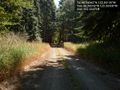
The road leading to the point. @46.5603,-123.3650

Me grinning, as close to the point as I could get. @.0000,.0000

Thwarted! @46.5600,-123.3650
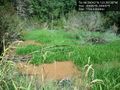
Thwarted again! This marshy land was between me and the point. @.0000,.0000
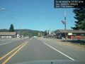
The sleepy town of Pe Ell, WA, along Route 6. Probably named for Superman's great-uncle. @.0000,.0000
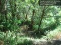
It was a rather nice walk in the woods. @.0000,.0000


Achievements