Difference between revisions of "2012-09-15 47 -122"
imported>OtherJack (→Expedition: write up expedition) |
imported>OtherJack m (→Photos) |
||
| Line 46: | Line 46: | ||
Image:2012-09-15_47_-122_16-57-34-454.jpg | At Clark Lake Park, just south of the geohash. [http://www.openstreetmap.org/?lat=47.38378494&lon=-122.17388085&zoom=16&layers=B000FTF @47.3838,-122.1739] | Image:2012-09-15_47_-122_16-57-34-454.jpg | At Clark Lake Park, just south of the geohash. [http://www.openstreetmap.org/?lat=47.38378494&lon=-122.17388085&zoom=16&layers=B000FTF @47.3838,-122.1739] | ||
</gallery> | </gallery> | ||
| + | (Jack's photos coming later) | ||
== Achievements == | == Achievements == | ||
Revision as of 07:14, 16 September 2012
| Sat 15 Sep 2012 in Seattle: 47.3909236, -122.1767951 geohashing.info google osm bing/os kml crox |
Location
The front yard of a house in Kent.
Participants
Plans
Drive there on Saturday at 4pm, then continue to South Hill for a strategy game night.
- I could bike down, but having to be in the U-district till 2pm means that 4 would be cutting it close. Is 4:30 too late for your schedule? Alternatively I could bus/bike and certainly be there by 4. -- OtherJack 15:24, 14 September 2012 (EDT)
Expedition
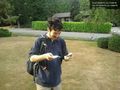
- Arrived Ikea -- Thomcat @47.4433,-122.2245 15:47, 15 September 2012 (PDT)
...and about 45 minutes after that post (4:33pm) we arrived in front of the hash house, within about 30 seconds of each other. My bike ride was beautiful and straightforward, except for climbing up East Hill in Kent at the very end, which was heinously steep (Google indicates a 500-foot stretch of 16% grade, and a lot more than that in the 12% ballpark.) Thom promptly produced some Swedish candy from the Ikea, which turned out to be a somewhat nicer version of Kit-kats. No one seemed to be home at the house, so Thom went ahead and wandered onto their lawn, which was not watered or anything. This gave me moral cover to do the same, and within a few seconds we had the hashpoint. I forgot to take a GPS shot though - I hope you remembered Thom?
After brief conversation back at the vehicles, Thom drove on to his board game night and I headed home via 140th Ave SE, Ezell's chicken, the Cedar River trail (excellent, I'll have to come back sometime!) and the west shore of Lake Washington. Not a bad day.
-- OtherJack 03:10, 16 September 2012 (EDT)
Tracklog
Photos
On the spot! @47.3910,-122.1768
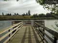
At Clark Lake Park, just south of the geohash. @47.3838,-122.1739


(Jack's photos coming later)
Achievements