Difference between revisions of "2012-09-18 50 8"
From Geohashing
imported>Jiml m (Adjust result codes) |
imported>LadyBB (new photo) |
||
| Line 27: | Line 27: | ||
== Photos == | == Photos == | ||
| − | |||
<!-- Insert pictures between the gallery tags using the following format: | <!-- Insert pictures between the gallery tags using the following format: | ||
| Line 33: | Line 32: | ||
--> | --> | ||
<gallery perrow="5"> | <gallery perrow="5"> | ||
| − | + | Image:2012 09 18 coordinates reached.png | Coordinates reached! | |
| − | Image:2012-09-18_50_8_21-45-10-095.jpg | | + | Image:2012-09-18_50_8_21-45-10-095.jpg | Stupid Grin |
</gallery> | </gallery> | ||
Revision as of 20:03, 20 September 2012
| Tue 18 Sep 2012 in 50,8: 50.1867725, 8.1845413 geohashing.info google osm bing/os kml crox |
Location
on a road in Taunusstein - between Orlen and Hambach
Participants
Plans
Drive through the hash after EmmJays afternoon nap and visit a friend on our way home.
Expedition
We started a little bit later than planned because we picked a couple of blackberries in the garden. Apart from that the plan worked well. After a 20 minutes drive to the hash and the drive through the hash we parked the car and went back to the coordinates to make a proper screenshot and the grin photo. After the stop in Neuhof we got back home around 8pm.
Tracklog
later, to document the Drive through.
Photos
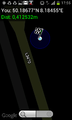
Coordinates reached!

Stupid Grin


Achievements
- Land geohash