Difference between revisions of "2012-10-02 -35 149"
imported>1PE (→Location) |
imported>1PE |
||
| Line 1: | Line 1: | ||
| − | + | [[Image:{{{image|2012-10-02 -35 149 tree-hash.JPG}}}|thumb|right]] | |
| − | |||
| − | |||
| − | |||
| − | |||
| − | |||
| − | |||
| − | |||
{{meetup graticule | {{meetup graticule | ||
| lat=-35 | | lat=-35 | ||
| Line 34: | Line 27: | ||
Uneventful trip down the highway and then along Tharwa Drive through the southern suburbs. Tharwa Drive passes Lanyon, and I stopped to take pictures of the signage before driving in and along the access road. There were cattle on the road at the cattle grid that stops them exiting the property but allows cars to come/go without having to open/close a gate. | Uneventful trip down the highway and then along Tharwa Drive through the southern suburbs. Tharwa Drive passes Lanyon, and I stopped to take pictures of the signage before driving in and along the access road. There were cattle on the road at the cattle grid that stops them exiting the property but allows cars to come/go without having to open/close a gate. | ||
| − | I stopped beside the dam that is over the road from the hash point. The tree marking the hash was about 15-20m off the road. I recorded the hash, then drove further to the Lanyon Homestead. I went into the foyer and handed the ActiveGeohasher sheet to the staff members and explained the ethos of geohashing. I was given a brochure and poster, which can be seen in one picture below; the door of the homestead on the broachure in front of the | + | I stopped beside the dam that is over the road from the hash point. The tree marking the hash was about 15-20m off the road. I recorded the hash, then drove further to the Lanyon Homestead. I went into the foyer and handed the ActiveGeohasher sheet to the staff members and explained the ethos of geohashing. I was given a brochure and poster, which can be seen in one picture below; the ''grand'' door of the homestead on the broachure in front of the ''front'' door. |
== Photos == | == Photos == | ||
| Line 41: | Line 34: | ||
--> | --> | ||
<gallery perrow="5"> | <gallery perrow="5"> | ||
| − | + | file:2012-10-02 -35 149 gate.JPG|Lanyon entrance, on Tharwa Drive. We are under video surveillance! | |
| + | file:2012-10-02 -35 149 tree-hash.JPG|A tree is a hash; a hash is a tree. | ||
| + | file:2012-10-02 -35 149 tree-hash2.JPG|V-tree (on left) in context, with road and dam. | ||
| + | file:2012-10-02 -35 149 Lanyon.JPG|Lanyon House, circa 1835 plus later mods. | ||
| + | file:2012-10-02 -35 149 booty.JPG|Booty of the visit: brochure showing grand door, and the front door! | ||
| + | file:2012-10-02 -35 149 tree-hash3.JPG|Hash trees from the road. | ||
| + | file:2012-10-02 -35 149 cattle.JPG|A working farm. | ||
</gallery> | </gallery> | ||
Revision as of 13:16, 2 October 2012
| Tue 2 Oct 2012 in -35,149: -35.4867659, 149.0835461 geohashing.info google osm bing/os kml crox |
Location
At a tree beside the road in the 'top' paddock of Lanyon, an historic farm now bordered by the southern suburbs of Canberra.
The farm features Lanyon Homestead, now an historic site and museum. The farm and homestead were established in 1935/6 by James Wright and John Lanyon, then continued by Wright until sold in 1847. It had convict labour in the early days. The farm was privately owned until 1974 after which it has been operated by the Government of the Australian Capital Territory.
A bequest of paintings by the renowned artist, Sir Sidney Nolan, was housed at Lanyon for many years, first in the main house then in a purpose-built gallery.
Participants
Plans
1PE
Lunchtime, driving down the Monaro Highway.
Expedition
1PE
Uneventful trip down the highway and then along Tharwa Drive through the southern suburbs. Tharwa Drive passes Lanyon, and I stopped to take pictures of the signage before driving in and along the access road. There were cattle on the road at the cattle grid that stops them exiting the property but allows cars to come/go without having to open/close a gate.
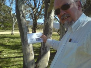
I stopped beside the dam that is over the road from the hash point. The tree marking the hash was about 15-20m off the road. I recorded the hash, then drove further to the Lanyon Homestead. I went into the foyer and handed the ActiveGeohasher sheet to the staff members and explained the ethos of geohashing. I was given a brochure and poster, which can be seen in one picture below; the grand door of the homestead on the broachure in front of the front door.


