Difference between revisions of "2012-10-04 45 -121"
imported>Kydlt (→Achievements) |
imported>Benjw (remove unwanted bits of template and add cats) |
||
| Line 1: | Line 1: | ||
| − | |||
| − | |||
| − | |||
| − | |||
| − | |||
| − | |||
| − | |||
| − | |||
| − | |||
{{meetup graticule | {{meetup graticule | ||
| lat=45 | | lat=45 | ||
| Line 13: | Line 4: | ||
| date=2012-10-04 | | date=2012-10-04 | ||
}} | }} | ||
| − | |||
| − | |||
__NOTOC__ | __NOTOC__ | ||
== Location == | == Location == | ||
| Line 33: | Line 22: | ||
== Tracklog == | == Tracklog == | ||
| − | |||
| − | |||
<gallery> | <gallery> | ||
File:2012-10-04 45 -121 10 screen capture of track.JPG|The trail on the map sure didn't match the trail on the hillside. | File:2012-10-04 45 -121 10 screen capture of track.JPG|The trail on the map sure didn't match the trail on the hillside. | ||
| Line 53: | Line 40: | ||
Not reached | Not reached | ||
| + | |||
| + | [[Category:Expeditions]] | ||
| + | [[Category:Coordinates not reached]] | ||
| + | [[Category:Not reached - Mother Nature]] | ||
Revision as of 17:58, 6 June 2013
| Thu 4 Oct 2012 in 45,-121: 45.8146961, -121.9287584 geohashing.info google osm bing/os kml crox |
Location
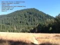
Bunker Hill.
Participants
Plans
Get out and take a walk on the PCT. Then look for a trail that goes up Bunker Hill. There should be one somewhere.
Expedition
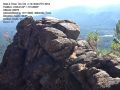
I didn't get to the hash. It was 450 feet to the east, and 350 feet down from my closest approach. But I know why I play this game. In a short phrase : places like Bunker Hill, outside Carson WA. From the car, a 2 miles hike, up from 1083 elev to 2368 ft at the hill top. And 1125 vertical feet in the 5030 lineal feet from the junction of the PCT to the top of the hill. The view was nice.
Tracklog
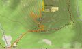
The trail on the map sure didn't match the trail on the hillside.

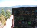
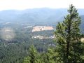
Photos
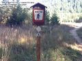
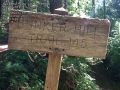
The US's SuperTrail, The PCT
There it sits, kinda sudden and surrounded by flat.
The PCT is so nice and flat. Relatively speaking.
I love the views, but I hate walking out there.
I've been using the ipad instead of my DeLorme more.
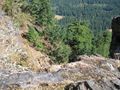
Looking over the edge, the hash is out 450 ft and down 350.
It's the only way I get high anymore.


Achievements
Not reached