Difference between revisions of "2012-10-09 32 -117"
From Geohashing
imported>LucasBrown (→Photos) |
imported>LucasBrown |
||
| Line 1: | Line 1: | ||
| − | |||
| − | |||
| − | |||
| − | |||
| − | |||
| − | |||
| − | |||
| − | |||
| − | |||
| − | |||
{{meetup graticule | {{meetup graticule | ||
| lat=32 | | lat=32 | ||
| Line 15: | Line 5: | ||
}} | }} | ||
| − | |||
__NOTOC__ | __NOTOC__ | ||
== Location == | == Location == | ||
| − | + | Just outside Serra Mesa Park, just south of Aero Drive | |
| − | |||
| − | |||
== Participants == | == Participants == | ||
| − | |||
* - [[User:Mathgeek|Mathgeek]] | * - [[User:Mathgeek|Mathgeek]] | ||
| Line 29: | Line 15: | ||
== Plans == | == Plans == | ||
| − | |||
| − | |||
*This seems doable today... In or around a park near Aero Dr. and Ruffin Rd. Perhaps on my way home from work. -- [[User:Mathgeek|Mathgeek]] 10:04, 9 October 2012 (PDT) | *This seems doable today... In or around a park near Aero Dr. and Ruffin Rd. Perhaps on my way home from work. -- [[User:Mathgeek|Mathgeek]] 10:04, 9 October 2012 (PDT) | ||
== Expedition == | == Expedition == | ||
| − | |||
| − | |||
| − | |||
*A lovely location in a park past the left field fence. -- [[User:Mathgeek|Mathgeek]] [http://www.openstreetmap.org/?lat=32.80673226&lon=-117.13171700&zoom=16&layers=B000FTF @32.8067,-117.1317] 17:31, 9 October 2012 (PDT) | *A lovely location in a park past the left field fence. -- [[User:Mathgeek|Mathgeek]] [http://www.openstreetmap.org/?lat=32.80673226&lon=-117.13171700&zoom=16&layers=B000FTF @32.8067,-117.1317] 17:31, 9 October 2012 (PDT) | ||
| − | |||
| − | |||
== Photos == | == Photos == | ||
| Line 61: | Line 40: | ||
| − | |||
| − | |||
[[Category:New report]] | [[Category:New report]] | ||
| − | |||
| − | |||
| − | |||
| − | |||
| − | |||
| − | |||
| − | |||
[[Category:Expeditions]] | [[Category:Expeditions]] | ||
| − | |||
[[Category:Expeditions with photos]] | [[Category:Expeditions with photos]] | ||
| − | |||
[[Category:Expedition without GPS]] | [[Category:Expedition without GPS]] | ||
| − | |||
| − | |||
| − | |||
[[Category:Coordinates reached]] | [[Category:Coordinates reached]] | ||
| − | |||
| − | |||
| − | |||
| − | |||
| − | |||
| − | |||
| − | |||
| − | |||
| − | |||
| − | |||
| − | |||
| − | |||
| − | |||
| − | |||
| − | |||
| − | |||
| − | |||
| − | |||
Revision as of 02:15, 10 October 2012
| Tue 9 Oct 2012 in 32,-117: 32.8067439, -117.1316724 geohashing.info google osm bing/os kml crox |
Location
Just outside Serra Mesa Park, just south of Aero Drive
Participants
- - Mathgeek
LucasBrown reached the hashpoint at about 18:30 PDT
Plans
- This seems doable today... In or around a park near Aero Dr. and Ruffin Rd. Perhaps on my way home from work. -- Mathgeek 10:04, 9 October 2012 (PDT)
Expedition
- A lovely location in a park past the left field fence. -- Mathgeek @32.8067,-117.1317 17:31, 9 October 2012 (PDT)
Photos
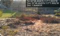
Open area in the park. @32.8067,-117.1317

Here I be. @32.8068,-117.1317
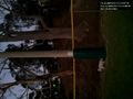
(LucasBrown) The hashpoint is atop the small rise behind the post. @32.8065,-117.1319

(LucasBrown) A sign left on the post @32.8065,-117.1320
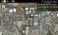
(LucasBrown) Map at the hashpoint @32.8064,-117.1320
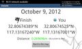
(LucasBrown) Geohash Droid details page at the hashpoint @32.8062,-117.1320


