Difference between revisions of "2012-10-12 43 -89"
From Geohashing
imported>Swensonj (categories, kill tracklog, first announcement, photos) |
imported>Swensonj (bring photos online, captions, list achievements) |
||
| Line 20: | Line 20: | ||
== Photos == | == Photos == | ||
| − | |||
<gallery perrow="3"> | <gallery perrow="3"> | ||
| − | Image:2012-10-12 43 -89 Tractor.jpg | | + | Image:2012-10-12 43 -89 Tractor.jpg | The tractor driver gave me permission to journey on |
| − | Image:2012-10-12 43 -89 Field.jpg | | + | Image:2012-10-12 43 -89 Field.jpg | View from parking place across the hashpoint |
| − | Image:2012-10-12 43 -89 Proof.jpg | | + | Image:2012-10-12 43 -89 Proof.jpg | I got there! |
| − | Image:2012-10-12 43 -89 Park.jpg | | + | Image:2012-10-12 43 -89 Park.jpg | A hash one mile to the east would have been more fun (and earned the [[Admit One Geohash]] achievement) |
| − | Image:2012-10-12 43 -89 Squishy.jpg | | + | Image:2012-10-12 43 -89 Squishy.jpg | Cheers! |
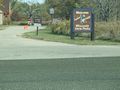
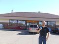
| − | Image:2012-10-12 43 -89 MATC.jpg | | + | Image:2012-10-12 43 -89 MATC.jpg | Madison College, main entrance |
</gallery> | </gallery> | ||
| − | |||
== Achievements == | == Achievements == | ||
{{#vardefine:ribbonwidth|800px}} | {{#vardefine:ribbonwidth|800px}} | ||
| − | |||
| + | {{land geohash | ||
| + | |||
| + | | latitude = 43 | ||
| + | | longitude = -89 | ||
| + | | date = 2012-10-12 | ||
| + | | name = SwensonJ | ||
| + | | image = 2012-10-12_43_-89 Proof.jpg | ||
| + | |||
| + | }} | ||
| + | |||
| + | {{GeoSquishy FirstSip | ||
| + | |||
| + | | latitude = 43 | ||
| + | | longitude = -89 | ||
| + | | date = 2012-10-12 | ||
| + | | name = SwensonJ | ||
| + | | image = 2012-10-12_43_-89 Squishy.jpg | ||
| + | <!-- 2 stars: | ||
| + | distance from hash (43.1332032,-89.4555498) | ||
| + | to squishy (43.150941,-89.414291) | ||
| + | is 3.8896 km. | ||
| + | Tools: | ||
| + | http://itouchmap.com/latlong.html | ||
| + | http://www2.nau.edu/~cvm/latlongdist.html | ||
| + | --> | ||
| + | |||
| + | }} | ||
| + | {{Minesweeper geohash | ||
| + | |||
| + | | graticule = Dubuque, Iowa | ||
| + | | ranknumber = 3 | ||
| + | | n = true | ||
| + | | ne = true | ||
| + | | w = true | ||
| + | | name = SwensonJ | ||
| + | |||
| + | }} | ||
<!-- =============== USEFUL CATEGORIES FOLLOW ================ | <!-- =============== USEFUL CATEGORIES FOLLOW ================ | ||
Revision as of 16:35, 13 October 2012
| Fri 12 Oct 2012 in 43,-89: 43.1332032, -89.4555498 geohashing.info google osm bing/os kml crox |
Location
Farmland northwest of Lake Mendota, near Governor Nelson State Park
Participants
Plans
SwensonJ is driving to Madison for a 3:00 appointment. He'll try to swing by the hash on the way there, sometime in the early afternoon.
Expedition
Success! More soon.
Photos
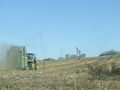
The tractor driver gave me permission to journey on
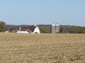
View from parking place across the hashpoint
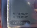
I got there!
A hash one mile to the east would have been more fun (and earned the Admit One Geohash achievement)
Cheers!
Madison College, main entrance


Achievements
SwensonJ earned the Land geohash achievement
|
SwensonJ earned the First Sip GeoSquishy Achievement
|
SwensonJ achieved level 3 of the Minesweeper Geohash achievement
|