Difference between revisions of "2012-10-18 59 18"
imported>Per S m (→Photos) |
imported>FippeBot m (Location) |
||
| Line 57: | Line 57: | ||
[[Category: Expeditions with photos]] | [[Category: Expeditions with photos]] | ||
[[Category: Coordinates reached]] | [[Category: Coordinates reached]] | ||
| + | {{location|SE|AB}} | ||
Latest revision as of 06:34, 13 August 2019

|
| ||||||
Location
Close to the road at Båtkroksvägen 5, Stavsnäs, Sweden
Participants
Plans
Wow. This hash is only 20 feet (6 m) away from the hash i visited on July 21, 2011.
I will try to drive to this hashpoint after work and hopefully catch the last rays of daylight.
Expedition
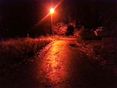
I started out at about 5:20 p.m. and drove out to the Hashpoint. It was about 20 miles. The hashpoint was visible from the road and accessible by foot. It was right next to a house/cabin, but outside the property.
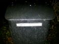
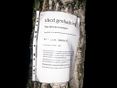
It was already dark when I arrived, but I tried to take matching pictures to the ones I took on the last trip. The xkcd marker from last year was not there anymore, but I took a picture in the same spot and put up a marker on a tree a few yards away. The notice board next to the roadsign had been replaced and the neighbours had gotten a new mailbox.
I didn't get a screen shot of the Geohash Droid app when I was at the hash, though :( I have a new phone and failed to press the "save" check mark after taking the screen shot.
Photos

Today's citation

Road sign
The road
Next door

Coordinates reached

The geohasher
Marker


Achievements
Per S earned the Déjà Vu Geohash Achievement
|