Difference between revisions of "2012-11-11 50 8"
From Geohashing
imported>Rincewind (→Expedition) |
imported>FippeBot m (Location) |
||
| Line 47: | Line 47: | ||
[[Category:Expeditions with photos]] | [[Category:Expeditions with photos]] | ||
[[Category:Coordinates reached]] | [[Category:Coordinates reached]] | ||
| + | {{location|DE|HE|GI}} | ||
Latest revision as of 06:51, 13 August 2019
| Sun 11 Nov 2012 in 50,8: 50.6033624, 8.6477091 geohashing.info google osm bing/os kml crox |
Location
On a field near Wettenberg, Hessen.
Participants
Plans
To use a rainless morning after a day full of rain.
Expedition
That was an easy well-situated hash. On the bridge we were met by a large herd of sheep. We had to wait until they all descended. Without haste, real Sunday sheep :) The hash coordinates were on some pasture and so well-grazed it was absolutely easy walking there- almost like a golf course. Hash success, again.
Photos
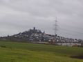
Nice landscape with a castle, bad phone camera digital zoom.
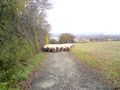
Retreating sheep on our way to the coordinates.
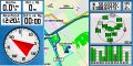
So, we've been there.

The beauty and the beast (from right).
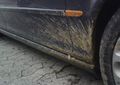
Somehow, it always ends like this.


Achievements
Yakamoz and Rincewind earned the Land geohash achievement
|