Difference between revisions of "2012-11-17 32 -116"
From Geohashing
imported>LucasBrown |
imported>Calamus m (Categorizing) |
||
| Line 16: | Line 16: | ||
</gallery> | </gallery> | ||
| − | |||
[[Category:Expeditions]] | [[Category:Expeditions]] | ||
[[Category:Expeditions with photos]] | [[Category:Expeditions with photos]] | ||
[[Category:Expedition without GPS]] | [[Category:Expedition without GPS]] | ||
[[Category:Coordinates reached]] | [[Category:Coordinates reached]] | ||
Revision as of 09:32, 30 November 2012
| Sat 17 Nov 2012 in 32,-116: 32.7753100, -116.8081920 geohashing.info google osm bing/os kml crox |
Location
On a boulder off Sloane Canyon Road, southwest of Loveland Reservoir
Participants
Photos
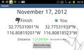
Geohash Droid details page at the hashpoint
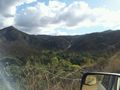
Scenery near the hashpoint
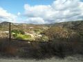
Looking southeast from the hashpoint
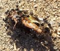
A bug being devoured by ants near the hashpoint


