Difference between revisions of "2012-12-31 33 -117"
From Geohashing
imported>LucasBrown (→Photos) |
imported>LucasBrown (→Photos) |
||
| Line 12: | Line 12: | ||
Image:2012-12-31_33_-117_15-48-17-149.jpg | Map about 100m from the hashpoint | Image:2012-12-31_33_-117_15-48-17-149.jpg | Map about 100m from the hashpoint | ||
Image:2012-12-31_33_-117_15-49-51-910.jpg | Sign posted near the hashpoint | Image:2012-12-31_33_-117_15-49-51-910.jpg | Sign posted near the hashpoint | ||
| − | Image:2012-12-31_33_-117_cliff.jpg | [[User:LucasBrown|LucasBrown]] attempting to climb the cliff | + | Image:2012-12-31_33_-117_cliff.jpg | [[User:LucasBrown|LucasBrown]] attempting to climb the cliff. The cliff turned out to be highly decomposed granite and catastrophically lost structural integrity shortly after this picture was taken. |
</gallery> | </gallery> | ||
Revision as of 00:48, 1 January 2013
| Mon 31 Dec 2012 in 33,-117: 33.1684853, -117.0080529 geohashing.info google osm bing/os kml crox |
Location
About 60 meters off the road near Lake Wohlford
Participants
Photos
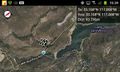
Map about 100m from the hashpoint

Sign posted near the hashpoint
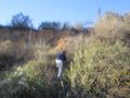
LucasBrown attempting to climb the cliff. The cliff turned out to be highly decomposed granite and catastrophically lost structural integrity shortly after this picture was taken.


Achievements
LucasBrown earned the Cliffs of Despair consolation prize
|