Difference between revisions of "2013-02-09 49 9"
imported>Danatar m (backbone, report will follow) |
imported>Danatar (Report) |
||
| Line 12: | Line 12: | ||
Country: Germany; state: Bayern (Bavaria, EU:DE:BY); administrative region: Unterfranken; district: Würzburg City district | Country: Germany; state: Bayern (Bavaria, EU:DE:BY); administrative region: Unterfranken; district: Würzburg City district | ||
| − | Weather: clouded, a few single | + | Weather: clouded, a few single snowflakes, between -1 and 0 °C |
| Line 18: | Line 18: | ||
===[[User:Danatar|Danatar]]=== | ===[[User:Danatar|Danatar]]=== | ||
| − | ... | + | My first expedition this year. After lunch with my parents I started to walk towards the hashpoint. It was a nice walk, mostly uphill. At 15:50 I was near the hashpoint and recognized the area, because in December I cycled along that street while looking for a friend's house. From the satellite image I knew that the hashpoint would be right between two of the large apartment buildings, but the GPS jumped around a bit. I found the correct coordinates just at the front door of the southern building, but before I could take a picture the coordinates jumped again, this time to the other side of the building. So after visiting all three hashpoints I waited for 4 p.m., although I didn't expect any other geohashers. |
| + | Then I continued along the street and took a different route home. I had to walk some detours but I got home without crossing my own track. In total I walked 7.3 km on a Tron route. | ||
| − | |||
<gallery> | <gallery> | ||
| − | File:2013-02- | + | File:2013-02-09_49_9_gps.jpg|GPS |
File:2013-02-09_49_9_hp.jpg|coordinates reached! | File:2013-02-09_49_9_hp.jpg|coordinates reached! | ||
File:2013-02-09_49_9_spot-sat.jpg|the hashpoint, according to the satellite image | File:2013-02-09_49_9_spot-sat.jpg|the hashpoint, according to the satellite image | ||
Revision as of 19:47, 10 February 2013
| Sat 9 Feb 2013 in Würzburg: 49.7752334, 9.9595604 geohashing.info google osm bing/os kml crox |
Location
Today's location is next to a house in Würzburg
Country: Germany; state: Bayern (Bavaria, EU:DE:BY); administrative region: Unterfranken; district: Würzburg City district
Weather: clouded, a few single snowflakes, between -1 and 0 °C
Expedition
Danatar
My first expedition this year. After lunch with my parents I started to walk towards the hashpoint. It was a nice walk, mostly uphill. At 15:50 I was near the hashpoint and recognized the area, because in December I cycled along that street while looking for a friend's house. From the satellite image I knew that the hashpoint would be right between two of the large apartment buildings, but the GPS jumped around a bit. I found the correct coordinates just at the front door of the southern building, but before I could take a picture the coordinates jumped again, this time to the other side of the building. So after visiting all three hashpoints I waited for 4 p.m., although I didn't expect any other geohashers.
Then I continued along the street and took a different route home. I had to walk some detours but I got home without crossing my own track. In total I walked 7.3 km on a Tron route.
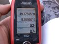
GPS
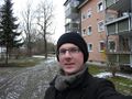
coordinates reached!
the hashpoint, according to the satellite image
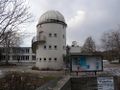
public observatory near the hashpoint
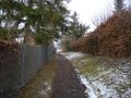
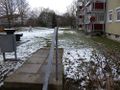
the smallest path I took
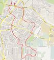
Tron route


