Difference between revisions of "2013-02-09 32 -96"
From Geohashing
imported>QuarterCacher |
imported>Mampfred m |
||
| Line 1: | Line 1: | ||
| − | + | {{meetup graticule | |
| lat=32 | | lat=32 | ||
| lon=-96 | | lon=-96 | ||
| Line 8: | Line 8: | ||
__NOTOC__ | __NOTOC__ | ||
== Location == | == Location == | ||
| − | + | <!-- where you've surveyed the hash to be --> | |
| − | |||
== Participants == | == Participants == | ||
| Line 15: | Line 14: | ||
== Plans == | == Plans == | ||
| − | + | <!-- what were the original plans --> | |
| − | |||
| − | |||
| − | |||
| − | |||
| − | |||
| − | |||
| − | |||
| − | |||
| − | |||
| − | |||
| − | |||
| − | |||
| − | |||
| + | == Expedition == | ||
| + | <!-- how it all turned out. your narrative goes here. --> | ||
Coordinates reached. :-) | Coordinates reached. :-) | ||
Revision as of 12:28, 24 February 2013
| Sat 9 Feb 2013 in 32,-96: 32.7752334, -96.9595604 geohashing.info google osm bing/os kml crox |
Location
Participants
Plans
Expedition
Coordinates reached. :-)
Tracklog
Photos

Finally! Today the hash point für the DFW graticule was reachable and near enough. On my last day!
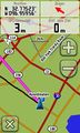
Coordinates reached but I had to walk around for some minutes due to jumping target. ;-)

