Difference between revisions of "2013-02-15 52 1"
imported>MagicIan (Created page with "== Location == Just off the path by Reedham Ferry Inn on the Norfolk Broads {{meetup graticule | lat=52 | lon=1 | date=2013-02-15 | graticule_name=Norwich | graticule_link=Norw...") |
imported>MagicIan |
||
| Line 29: | Line 29: | ||
== Photos == | == Photos == | ||
| − | + | <gallery perrow="4"> | |
| + | Image:130215_swans.JPG|Photo of swans on the way to the hashpoint for Friday 2013-02-15, 52.559777° 1.553342° (Norwich, United Kingdom) | ||
| + | Image:130215_windmill.JPG|Photo of old windmill on the way to the hashpoint for Friday 2013-02-15, 52.559777° 1.553342° (Norwich, United Kingdom) | ||
| + | Image:130215_caution.JPG|Photo of sign on the way to the hashpoint for Friday 2013-02-15, 52.559777° 1.553342° (Norwich, United Kingdom) | ||
| + | Image:130215_ferry.JPG|Photo of Reedham chain ferry on the way to the hashpoint for Friday 2013-02-15, 52.559777° 1.553342° (Norwich, United Kingdom) | ||
| + | Image:130215_ferry2.JPG|Photo of Reedham chain ferry on the way to the hashpoint for Friday 2013-02-15, 52.559777° 1.553342° (Norwich, United Kingdom) | ||
| + | Image:130215_pub.JPG|Photo of Reedham Ferry Inn on the way to the hashpoint for Friday 2013-02-15, 52.559777° 1.553342° (Norwich, United Kingdom) | ||
| + | Image:130215_bait.JPG|Photo of bait vending machine on the way to the hashpoint for Friday 2013-02-15, 52.559777° 1.553342° (Norwich, United Kingdom) | ||
| + | Image:130215_house.JPG|Photo of old windmill converted into a house on the way to the hashpoint for Friday 2013-02-15, 52.559777° 1.553342° (Norwich, United Kingdom) | ||
| + | Image:130215_hashpoint.JPG|Photo showing the view from the hashpoint for Friday 2013-02-15, 52.559777° 1.553342° (Norwich, United Kingdom) | ||
| + | Image:130215_tornado.JPG|Photo of one of four Tornado fighter jets that flew ahead on the post-hashpoint expedition for Friday 2013-02-15, 52.559777° 1.553342° (Norwich, United Kingdom) | ||
| + | Image:130215_Loddon.JPG|Photo of Loddon on the post-hashpoint expedition for Friday 2013-02-15, 52.559777° 1.553342° (Norwich, United Kingdom) | ||
| + | Image:130215_Loddon2.JPG|Photo of Loddon saithe on the post-hashpoint expedition for Friday 2013-02-15, 52.559777° 1.553342° (Norwich, United Kingdom) | ||
| + | Image:130215_Heron.JPG|Photo of a young heron on the post-hashpoint expedition for Friday 2013-02-15, 52.559777° 1.553342° (Norwich, United Kingdom) | ||
| + | Image:130215_danger.JPG|Photo of sign on the post-hashpoint expedition for Friday 2013-02-15, 52.559777° 1.553342° (Norwich, United Kingdom) | ||
| + | Image:130215_reflection1.JPG|Photo of amazing reflections on the water on the post-hashpoint expedition for Friday 2013-02-15, 52.559777° 1.553342° (Norwich, United Kingdom) | ||
| + | Image:130215_kayak.JPG|Photo of Magician's kayak on the post-hashpoint expedition for Friday 2013-02-15, 52.559777° 1.553342° (Norwich, United Kingdom) | ||
| + | Image:130215_river.JPG|Photo of amazing reflections on the river on the post-hashpoint expedition for Friday 2013-02-15, 52.559777° 1.553342° (Norwich, United Kingdom) | ||
| + | Image:130215_sunset.JPG|Photo of amazing reflections on the water on the post-hashpoint expedition for Friday 2013-02-15, 52.559777° 1.553342° (Norwich, United Kingdom) | ||
| + | Image:130215_boats.JPG|Photo of moored boats on the post-hashpoint expedition for Friday 2013-02-15, 52.559777° 1.553342° (Norwich, United Kingdom) | ||
| + | </gallery> | ||
Revision as of 21:29, 25 February 2013
Location
Just off the path by Reedham Ferry Inn on the Norfolk Broads
| Fri 15 Feb 2013 in Norwich: 52.5597772, 1.5533424 geohashing.info google osm bing/os kml crox |
Participants
Expedition
This hashpoint was for the Friday but MagicIan achieved it on Saturday 16th as Saturday's hashpoint was in the middle of the North Sea and he didn't fancy trying to get there!
It also combined with a perfect day to go kayaking. The temperature had risen a few degrees so he was able to just wear a base layer and a sprayproof outer layer. There was virtually no wind so the water was perfectly calm and gave perfect reflections. And not being tourist season, he only saw 1 moving boat in 4.5 hours on what is usually a busy stretch of river.
He launched from Hardley Dyke at around 11:15 and paddled along the river to Reedham Ferry where he got out at the pub and walked along the path, past the converted windmill, through a couple of gates to the hashpoint. He got within a couple of meters without getting muddy feet.
After reaching the hashpoint he then made the most of the day to paddle all the way to Loddon and back - a total of 10.8 miles in a type of kayak not at all suited to flat water!
Achievements
This was the second hashpoint that MagicIan had reached using his kayak. Unfortunately neither were located on the water, hence he couldn't claim a Water Geohash. And he didn't get wet so can't claim a Drowed Rat award either.
Photos
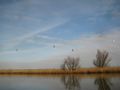
Photo of swans on the way to the hashpoint for Friday 2013-02-15, 52.559777° 1.553342° (Norwich, United Kingdom)
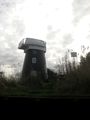
Photo of old windmill on the way to the hashpoint for Friday 2013-02-15, 52.559777° 1.553342° (Norwich, United Kingdom)
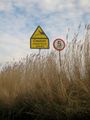
Photo of sign on the way to the hashpoint for Friday 2013-02-15, 52.559777° 1.553342° (Norwich, United Kingdom)
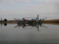
Photo of Reedham chain ferry on the way to the hashpoint for Friday 2013-02-15, 52.559777° 1.553342° (Norwich, United Kingdom)
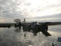
Photo of Reedham chain ferry on the way to the hashpoint for Friday 2013-02-15, 52.559777° 1.553342° (Norwich, United Kingdom)
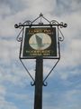
Photo of Reedham Ferry Inn on the way to the hashpoint for Friday 2013-02-15, 52.559777° 1.553342° (Norwich, United Kingdom)
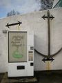
Photo of bait vending machine on the way to the hashpoint for Friday 2013-02-15, 52.559777° 1.553342° (Norwich, United Kingdom)
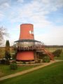
Photo of old windmill converted into a house on the way to the hashpoint for Friday 2013-02-15, 52.559777° 1.553342° (Norwich, United Kingdom)
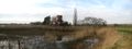
Photo showing the view from the hashpoint for Friday 2013-02-15, 52.559777° 1.553342° (Norwich, United Kingdom)
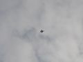
Photo of one of four Tornado fighter jets that flew ahead on the post-hashpoint expedition for Friday 2013-02-15, 52.559777° 1.553342° (Norwich, United Kingdom)
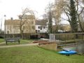
Photo of Loddon on the post-hashpoint expedition for Friday 2013-02-15, 52.559777° 1.553342° (Norwich, United Kingdom)
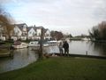
Photo of Loddon saithe on the post-hashpoint expedition for Friday 2013-02-15, 52.559777° 1.553342° (Norwich, United Kingdom)
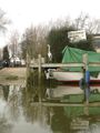
Photo of a young heron on the post-hashpoint expedition for Friday 2013-02-15, 52.559777° 1.553342° (Norwich, United Kingdom)
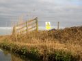
Photo of sign on the post-hashpoint expedition for Friday 2013-02-15, 52.559777° 1.553342° (Norwich, United Kingdom)
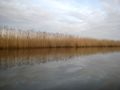
Photo of amazing reflections on the water on the post-hashpoint expedition for Friday 2013-02-15, 52.559777° 1.553342° (Norwich, United Kingdom)
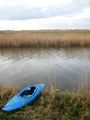
Photo of Magician's kayak on the post-hashpoint expedition for Friday 2013-02-15, 52.559777° 1.553342° (Norwich, United Kingdom)
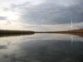
Photo of amazing reflections on the river on the post-hashpoint expedition for Friday 2013-02-15, 52.559777° 1.553342° (Norwich, United Kingdom)
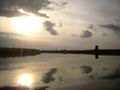
Photo of amazing reflections on the water on the post-hashpoint expedition for Friday 2013-02-15, 52.559777° 1.553342° (Norwich, United Kingdom)
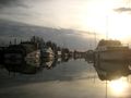
Photo of moored boats on the post-hashpoint expedition for Friday 2013-02-15, 52.559777° 1.553342° (Norwich, United Kingdom)


