Difference between revisions of "2013-02-21 52 1"
From Geohashing
imported>MagicIan (Created page with "== Location == On the edge of the road in Intwood, just outside the Norwich southern bypass. {{meetup graticule | lat=52 | lon=1 | date=2013-02-21 | graticule_name=Norwich | gr...") |
imported>MagicIan |
||
| Line 30: | Line 30: | ||
== Photos == | == Photos == | ||
| + | <gallery perrow="4"> | ||
| + | Image:130221_hashpoint.JPG|Photo of hashpoint for Thursday 2013-02-21, 52.590684° 1.243271° (Norwich, United Kingdom) | ||
| + | Image:130221_Droid.png|Phone screenshot showing proximity of the hashpoint for Thursday 2013-02-21, 52.590684° 1.243271° (Norwich, United Kingdom) | ||
| + | </gallery> | ||
| − | |||
<!-- Potential categories. Please include all the ones appropriate to your expedition --> | <!-- Potential categories. Please include all the ones appropriate to your expedition --> | ||
Revision as of 21:41, 25 February 2013
Location
On the edge of the road in Intwood, just outside the Norwich southern bypass.
| Thu 21 Feb 2013 in Norwich: 52.5906844, 1.2432712 geohashing.info google osm bing/os kml crox |
Participants
Expedition
Today's hash was at a place MagicIan had been very close to before. He looked it up whilst at work, and rode his bike direct from his workplace at the end of the day, reaching it just at dusk.
It was a short cycle (6.9 miles in total); cold, yet pleasant enough down normally quiet roads made busier at rush hour. The hashpoint itself was easily located under a large tree.
Achievements
MagicIan earned the Bicycle geohash achievement
|
Photos
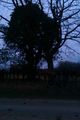
Photo of hashpoint for Thursday 2013-02-21, 52.590684° 1.243271° (Norwich, United Kingdom)
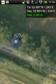
Phone screenshot showing proximity of the hashpoint for Thursday 2013-02-21, 52.590684° 1.243271° (Norwich, United Kingdom)

