Difference between revisions of "2013-02-28 46 7"
imported>TheOneRing (Created page with "{{meetup graticule | lat=46 | lon=7 | date=2013-02-28 }} == Location == The geohash is on a street (main street?) in Ittigen, close to Bern. == Who Went == [[User:TheOneRing...") |
imported>TheOneRing |
||
| Line 11: | Line 11: | ||
[[User:TheOneRing|TheOneRing]] - by public transport. | [[User:TheOneRing|TheOneRing]] - by public transport. | ||
| − | == The | + | == The Expedition == |
| − | I | + | This geohash was very close to Bern, so I wanted to take the opportunity after the winter break. Everything looked more like winter than at my [[2012-12-30 51 11 | last geohash attempt]], although that was also in winter time. Anyway, spring is coming, there was not much snow on the meadows anymore. |
| + | |||
| + | I planned to leave my office at 5 pm, but I could'nt leave before 5:30. I took a train to the station "Papiermühle" (paper mill) in Ittigen and walked about 1km to the geohash. The geohash itself was in the middle of a street, but stepping on it would have been suicidal: rush hour. Fortunately, the pavement was close enough. | ||
| + | |||
| + | The surrounding was not very impressive, I took the other photographs on the way back. | ||
== Photos == | == Photos == | ||
| + | <gallery perrow="4"> | ||
| + | Image:20130228_46_7Geohash.jpg|On the middle of the street, there is the geohash | ||
| + | Image:20130228_46_7GPS.jpg|Coordinates reached | ||
| + | Image:20130228_46_7Info.jpg|Some additional information | ||
| + | Image:20130228_46_7Me.jpg|Me, staring into the flashlight | ||
| + | Image:20130228_46_7Sunset.jpg|Sunset over Ittigen | ||
| + | Image:20130228_46_7Bantiger.jpg|The radio tower on the mountain Bantiger | ||
| + | Image:20130228_46_7Ittigen.jpg|Panoramic view over Ittigen | ||
| + | Image:20130228_46_7Train.jpg|I took this train | ||
| + | </gallery> | ||
== Achievements == | == Achievements == | ||
| + | {{land geohash | latitude = 46 | longitude = 7 | date = 2013-02-28 | name = TheOneRing}} | ||
| + | {{Public transport geohash | latitude = 46 | longitude = 7 | date = 2013-02-28 | name = TheOneRing }} | ||
| + | |||
| + | [[Category:Expeditions]] | ||
| + | [[Category:Expeditions with photos]] | ||
| + | [[Category:Coordinates reached]] | ||
Revision as of 19:48, 28 February 2013
| Thu 28 Feb 2013 in 46,7: 46.9823602, 7.4796696 geohashing.info google osm bing/os kml crox |
Location
The geohash is on a street (main street?) in Ittigen, close to Bern.
Who Went
TheOneRing - by public transport.
The Expedition
This geohash was very close to Bern, so I wanted to take the opportunity after the winter break. Everything looked more like winter than at my last geohash attempt, although that was also in winter time. Anyway, spring is coming, there was not much snow on the meadows anymore.
I planned to leave my office at 5 pm, but I could'nt leave before 5:30. I took a train to the station "Papiermühle" (paper mill) in Ittigen and walked about 1km to the geohash. The geohash itself was in the middle of a street, but stepping on it would have been suicidal: rush hour. Fortunately, the pavement was close enough.
The surrounding was not very impressive, I took the other photographs on the way back.
Photos
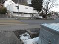
On the middle of the street, there is the geohash
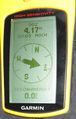
Coordinates reached
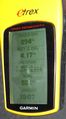
Some additional information

Me, staring into the flashlight
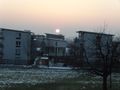
Sunset over Ittigen
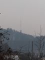
The radio tower on the mountain Bantiger
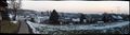
Panoramic view over Ittigen
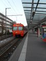
I took this train


Achievements
TheOneRing earned the Land geohash achievement
|
TheOneRing earned the Public transport geohash achievement
|