Difference between revisions of "2013-03-16 55 37"
From Geohashing
imported>Vb (→Plans) |
imported>Vb |
||
| Line 32: | Line 32: | ||
== Expedition == | == Expedition == | ||
<!-- how it all turned out. your narrative goes here. --> | <!-- how it all turned out. your narrative goes here. --> | ||
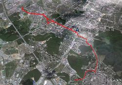
| − | Walked there, and half way back. ~4h in total, 20.92km. Temperature a bit higher than zero, humid but no rain. Many puddles from the melting snow. | + | Walked there, and half way back. ~4h in total, tracklog's length is 20.92km but GPS was significantly off on a couple of occasions, so it's more like, let's say, 20.4km. Temperature a bit higher than zero, humid but no rain. Many puddles from the melting snow. |
== Tracklog == | == Tracklog == | ||
<!-- if your GPS device keeps a log, you may post a link here --> | <!-- if your GPS device keeps a log, you may post a link here --> | ||
| + | [[Image:2013-03-16_55_37_Tracklog.jpg|250px]] | ||
== Photos == | == Photos == | ||
Revision as of 09:13, 17 March 2013
| Sat 16 Mar 2013 in 55,37: 55.6734163, 37.4521782 geohashing.info google osm bing/os kml crox |
Location
In Ochakovo-Matveyevskoye district, close to Troparyovo-Nikulino district.
Participants
Plans
The hash is either on the territory of kindergarten or close to it. Google imagery suggests the former, however accuracy of it is not known.
Expedition
Walked there, and half way back. ~4h in total, tracklog's length is 20.92km but GPS was significantly off on a couple of occasions, so it's more like, let's say, 20.4km. Temperature a bit higher than zero, humid but no rain. Many puddles from the melting snow.


