Difference between revisions of "2013-03-27 39 -77"
imported>GeorgDerReisende |
imported>FippeBot m (Location) |
||
| Line 56: | Line 56: | ||
[[Category:Expeditions with photos]] | [[Category:Expeditions with photos]] | ||
[[Category:Coordinates reached]] | [[Category:Coordinates reached]] | ||
| + | {{location|US|MD|CR}} | ||
Revision as of 01:36, 14 August 2019
| Wed 27 Mar 2013 in 39,-77: 39.5357028, -77.1074312 geohashing.info google osm bing/os kml crox |
Location
In a thicket near a quarry in Westminster, MD
Participants
OfficeLinebacker (talk)OfficeLinebacker
Plans
Expedition
Deviated from the GPS directions to navigate to a dirt track I saw in the satellite photos. The sign said something about a quarry--no NO TRESPASSING signs! Success!
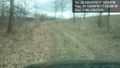
Drove a ways on a muddy dirt track. Long grasses an stems tickled the undercarriage of my car. Had to gun it through a couple of deep mud puddles. Once again the 4WD came in handy. I doubt my old Mazda Protege would have made it. At one point the muddy water splashed all over my hood and windshield and later, I noticed small clumps of mud on my roof. Once I parked, a deer path led me right to the spot.
Fairly straightforward. After this expedition, I headed to the hashpoint for the Baltimore graticule.
Tracklog
Photos

Silly grin @39.5357,-77.1074
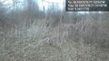
The spot @39.5357,-77.1074
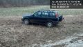
My trusty steed @39.5356,-77.1072
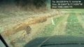
Part of the road there @39.5370,-77.1040
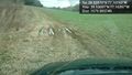
A mud bog I needed 4WD to get through @39.5370,-77.1040
The high vegetation scraped the undercarriage of my car here @39.5370,-77.1040


