Difference between revisions of "2013-04-05 43 -116"
imported>Eldin m (fix typo) |
imported>Jiml m (Result codes look right) |
||
| Line 11: | Line 11: | ||
== Participants == | == Participants == | ||
| − | [[User:Eldin|Eldin]] | + | * [[User:Eldin|Eldin]] |
== Expedition == | == Expedition == | ||
| − | I couldn't sleep. The hash was only about 10 miles from home. So I decided to drive out and see if it was reachable. I figured about a 50/50 chance that this would end in a 'no trespassing'. However, when I got there, I was able to walk to the hash point without seeing any signs or having to cross any fences. If it had not been a workday, this would have been a great bicycle geohash. But it was a bit far to bike as an after-work expedition. I'd hoped I might get there close enough to midnight to get the [[Midnight Geohash]] award, but I ended up getting there almost half an hour before midnight, and didn't really want to wait around for that long standing on some farmer's property in the middle of the night. In the end, the expedition was successful, but uneventful. | + | I couldn't sleep. The hash was only about 10 miles from home. So I decided to drive out and see if it was reachable. I figured about a 50/50 chance that this would end in a 'no trespassing'. |
| + | |||
| + | However, when I got there, I was able to walk to the hash point without seeing any signs or having to cross any fences. If it had not been a workday, this would have been a great bicycle geohash. But it was a bit far to bike as an after-work expedition. | ||
| + | |||
| + | I'd hoped I might get there close enough to midnight to get the [[Midnight Geohash]] award, but I ended up getting there almost half an hour before midnight, and didn't really want to wait around for that long standing on some farmer's property in the middle of the night. In the end, the expedition was successful, but uneventful. | ||
*Coordinates reached. -- [[User:Eldin|Eldin]] ([[User talk:Eldin|talk]]) [http://www.openstreetmap.org/?lat=43.49224053&lon=-116.37554952&zoom=16&layers=B000FTF @43.4922,-116.3755] 23:32, 5 April 2013 (MDT) | *Coordinates reached. -- [[User:Eldin|Eldin]] ([[User talk:Eldin|talk]]) [http://www.openstreetmap.org/?lat=43.49224053&lon=-116.37554952&zoom=16&layers=B000FTF @43.4922,-116.3755] 23:32, 5 April 2013 (MDT) | ||
| Line 24: | Line 28: | ||
</gallery> | </gallery> | ||
| − | + | == Achievements == | |
| + | |||
| + | * Land Geohash | ||
| + | |||
| + | |||
[[Category:Expeditions]] | [[Category:Expeditions]] | ||
| + | [[Category:Expeditions with photos]] | ||
[[Category:Coordinates reached]] | [[Category:Coordinates reached]] | ||
Revision as of 14:55, 6 April 2013
| Fri 5 Apr 2013 in 43,-116: 43.4922403, -116.3755388 geohashing.info google osm bing/os kml crox |
Location
At the edge of a farm on Locust Grove, near Kuna.
Participants
Expedition
I couldn't sleep. The hash was only about 10 miles from home. So I decided to drive out and see if it was reachable. I figured about a 50/50 chance that this would end in a 'no trespassing'.
However, when I got there, I was able to walk to the hash point without seeing any signs or having to cross any fences. If it had not been a workday, this would have been a great bicycle geohash. But it was a bit far to bike as an after-work expedition.
I'd hoped I might get there close enough to midnight to get the Midnight Geohash award, but I ended up getting there almost half an hour before midnight, and didn't really want to wait around for that long standing on some farmer's property in the middle of the night. In the end, the expedition was successful, but uneventful.
- Coordinates reached. -- Eldin (talk) @43.4922,-116.3755 23:32, 5 April 2013 (MDT)
Photos
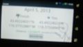
My camera wouldn't focus properly in the dark, but the proof is almost readable in this pic.

Achievements
- Land Geohash